|
search place name
|
||
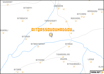
Aït Qassou Ou Haddou (Khenifra, Morocco)Aït Qassou Ou Haddou is a town in the Khenifra region of Morocco. An overview map of the region around Aït Qassou Ou Haddou is displayed below.
regional and 3d topo map of Aït Qassou Ou Haddou, Morocco ::
Aït Qassou Ou Haddou airports ::
The nearest airport is MEK - Meknes Bassatine, located 115.6 km north of Aït Qassou Ou Haddou.
Other airports nearby include FEZ - Fez Saiss (136.8 km north east), ERH - Er-rachidia Moulay Ali Cherif (157.1 km south east), RBA - Rabat Sale (166.2 km north west), NNA - Kentira Kenitra (181.8 km north west), Nearby towns ::
Tameskourt (5.0km north) //
Aït Bou Tarhat (5.4km south west) //
Aït Addi (6.1km south east) //
El Heri (5.9km east) //
Tiʼouinine (7.0km north east) //
Tighassaline (7.9km south east) //
Adekhsal (9.3km north east) //
[all distances 'as the bird flies' and approximate] 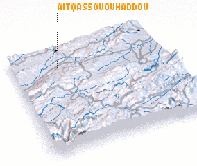 Places with similar names to Aït Qassou Ou Haddou, Morocco :: Disclaimer :: Information on this page comes without warranty of any kind |
||
|
Where is Aït Qassou Ou Haddou? Elevation and coordinates ::
Latitude (lat): 32°50'49"N Longitude (lon): 5°41'16"W
Elevation (approx.): 938m (map arrows pan, magnifying glasses zoom) |
||
|
Visiting Aït Qassou Ou Haddou? Hotel/Accommodation ::
Book a hotel in Aït Qassou Ou Haddou Travel Guide ::
Buy a travel guide for Morocco rental cars ::
car rental offers GPS waypoint ::
download a GPX waypoint (PoI) of Aït Qassou Ou Haddou for your GPS receiver
|
||