|
search place name
|
||
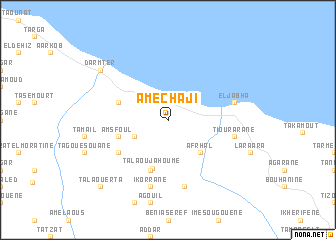
Amechaji (Chaouen, Morocco)Amechaji is a town in the Chaouen region of Morocco. An overview map of the region around Amechaji is displayed below.
regional and 3d topo map of Amechaji, Morocco ::
Amechaji airports ::
The nearest airport is TTU - Tetouan Saniat Rmel, located 69.0 km north west of Amechaji.
Other airports nearby include AHU - Al Hociema Cherif El Idrissi (81.4 km east), GIB - Gibraltar (119.4 km north west), TNG - Tanger Ibn Batouta (122.3 km north west), FEZ - Fez Saiss (143.0 km south), Nearby towns ::
Tasa (3.6km south west) //
Afrhâl (4.8km south east) //
Talaoujahoume (5.6km south) //
Jmedrane (4.9km west) //
Amsfoul (4.9km west) //
Menaat (5.8km south) //
Afrat (5.9km south west) //
El Jabha (6.3km east) //
Tiourarane (6.3km east) //
Tabarrant (6.3km east) //
Zademet el Fôki (7.6km south) //
Ikorrane (7.6km south) //
Dar Mter (8.2km north west) //
Tala Ouerta (9.6km south west) //
[all distances 'as the bird flies' and approximate] 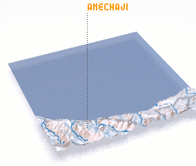 Places with similar names to Amechaji, Morocco ::
// Āima Shāhji (PK)
Disclaimer :: Information on this page comes without warranty of any kind |
||
|
Where is Amechaji? Elevation and coordinates ::
Latitude (lat): 35°12'0"N Longitude (lon): 4°44'0"W
Elevation (approx.): 173m (map arrows pan, magnifying glasses zoom) |
||
|
Visiting Amechaji? Hotel/Accommodation ::
Book a hotel in Amechaji Travel Guide ::
Buy a travel guide for Morocco rental cars ::
car rental offers GPS waypoint ::
download a GPX waypoint (PoI) of Amechaji for your GPS receiver
|
||