|
search place name
|
||
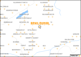
Arhil Oumial (Taza, Morocco)Arhil Oumial is a town in the Taza region of Morocco. An overview map of the region around Arhil Oumial is displayed below.
regional and 3d topo map of Arhil Oumial, Morocco ::
Arhil Oumial airports ::
The nearest airport is FEZ - Fez Saiss, located 92.9 km west of Arhil Oumial.
Other airports nearby include AHU - Al Hociema Cherif El Idrissi (125.7 km north), MEK - Meknes Bassatine (142.8 km west), MLN - Melilla (165.8 km north east), TTU - Tetouan Saniat Rmel (210.5 km north west), Nearby towns ::
Zaouiet el Mrabtine (2.4km north east) //
Oulad Ali Moussa (2.4km north east) //
Douar Tit Nteslit (3.1km west) //
Oulad al Haj (3.6km north east) //
Aït el Rhazi (3.6km south west) //
Beni Mester (3.6km north west) //
Tarzelt (4.8km south west) //
Issidane (5.0km east) //
Oulad Bou Azza (6.4km north east) //
Douar Tlajdout (6.4km south west) //
Tademant (6.4km west) //
Tafsest (7.6km south) //
Beni Khelou (6.4km west) //
Iabboudene (7.2km north east) //
Douar Tametrhout (7.2km north west) //
El Mehaouza (8.0km north) //
Tafrant (8.0km south west) //
El Oujik (8.3km south) //
Aïn el Aouda (8.3km north west) //
[all distances 'as the bird flies' and approximate]  Places with similar names to Arhil Oumial, Morocco :: Disclaimer :: Information on this page comes without warranty of any kind |
||
|
Where is Arhil Oumial? Elevation and coordinates ::
Latitude (lat): 34°3'0"N Longitude (lon): 3°59'0"W
Elevation (approx.): 1081m (map arrows pan, magnifying glasses zoom) |
||
|
Visiting Arhil Oumial? Hotel/Accommodation ::
Book a hotel in Arhil Oumial Travel Guide ::
Buy a travel guide for Morocco rental cars ::
car rental offers GPS waypoint ::
download a GPX waypoint (PoI) of Arhil Oumial for your GPS receiver
|
||