|
search place name
|
||
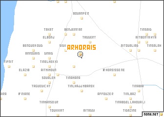
Arhoraïs (Agadir, Morocco)Arhoraïs is a town in the Agadir region of Morocco. An overview map of the region around Arhoraïs is displayed below.
regional and 3d topo map of Arhoraïs, Morocco ::
Arhoraïs airports ::
The nearest airport is AGA - Agadir Inezgane, located 19.2 km north of Arhoraïs.
Other airports nearby include RAK - Marrakech Menara (207.1 km north east), TTA - Tan Tan Plage Blanche (254.9 km south west), Nearby towns ::
Bakhir Atanane (2.4km south west) //
Taddert (4.0km north east) //
Sidi Bidi (3.7km north west) //
Ben Jerrar (5.8km north) //
Ti nʼAmara (5.8km south) //
Iachech (6.4km north west) //
Tou Zikou (6.1km south west) //
Draïd (6.4km west) //
Ti nʼ Lhajj Mbarek (7.4km south) //
Ti nʼ el Mekki (6.7km west) //
Irhoreïssene (7.4km south east) //
El Borj (7.4km north west) //
Aït Mimoun (7.4km south west) //
Takat (8.5km north west) //
Soualem (8.5km south west) //
[all distances 'as the bird flies' and approximate] 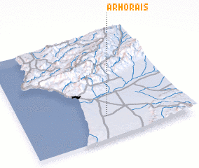 Places with similar names to Arhoraïs, Morocco :: Disclaimer :: Information on this page comes without warranty of any kind |
||
|
Where is Arhoraïs? Elevation and coordinates ::
Latitude (lat): 30°13'0"N Longitude (lon): 9°29'0"W
Elevation (approx.): 82m (map arrows pan, magnifying glasses zoom) |
||
|
Visiting Arhoraïs? Hotel/Accommodation ::
Book a hotel in Arhoraïs Travel Guide ::
Buy a travel guide for Morocco rental cars ::
car rental offers GPS waypoint ::
download a GPX waypoint (PoI) of Arhoraïs for your GPS receiver
|
||