|
search place name
|
||
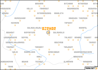
Azrhar (Al Hoceïma, Morocco)Azrhar is a town in the Al Hoceïma region of Morocco. An overview map of the region around Azrhar is displayed below.
regional and 3d topo map of Azrhar, Morocco ::
Azrhar airports ::
The nearest airport is AHU - Al Hociema Cherif El Idrissi, located 44.2 km north east of Azrhar.
Other airports nearby include MLN - Melilla (114.1 km north east), FEZ - Fez Saiss (129.9 km south west), TTU - Tetouan Saniat Rmel (140.7 km north west), MEK - Meknes Bassatine (169.0 km south west), Nearby towns ::
Iboulbrhene (0.0km north) //
Tazrot (1.9km north) //
Sidi el Hajj Youssef (1.9km north) //
Oulad Msila (3.0km east) //
Bou Zineb (4.8km south east) //
Ouaouizerht (5.6km south) //
Taïnest (4.6km west) //
Oulad el Haj Ali (4.9km west) //
Assaka (6.3km north west) //
Tarharit (6.3km south west) //
Tiiddiouine (7.4km south) //
Taïda (7.4km south) //
Aïn Fnâtene (6.1km west) //
Aïn Achboun (7.6km south) //
Talmest (6.4km east) //
Et Tnine des Beni Ammart (6.4km west) //
Aït Amar ou Saïd (7.6km north) //
Tafsest (7.1km north east) //
Mahaleth (8.0km north) //
Tamjount (8.2km south east) //
Tarhzo (8.7km north west) //
Oujdia (8.7km north west) //
Koulla (8.7km north west) //
Rhar el Kaïs (9.6km south west) //
[all distances 'as the bird flies' and approximate] 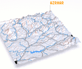 Places with similar names to Azrhar, Morocco ::
Disclaimer :: Information on this page comes without warranty of any kind |
||
|
Where is Azrhar? Elevation and coordinates ::
Latitude (lat): 34°50'0"N Longitude (lon): 4°5'0"W
Elevation (approx.): 1313m (map arrows pan, magnifying glasses zoom) |
||
|
Visiting Azrhar? Hotel/Accommodation ::
Book a hotel in Azrhar Travel Guide ::
Buy a travel guide for Morocco rental cars ::
car rental offers GPS waypoint ::
download a GPX waypoint (PoI) of Azrhar for your GPS receiver
|
||