|
search place name
|
||
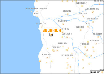
Bou Arich (Essaouira, Morocco)Bou Arich is a town in the Essaouira region of Morocco. An overview map of the region around Bou Arich is displayed below.
regional and 3d topo map of Bou Arich, Morocco ::
Bou Arich airports ::
The nearest airport is AGA - Agadir Inezgane, located 75.8 km south of Bou Arich.
Other airports nearby include RAK - Marrakech Menara (178.0 km east), Nearby towns ::
Tiguemmi Tigoudzine (3.2km east) //
Aït Iggui Fraks (3.7km north east) //
Tabaïat (4.4km south) //
Adouz nʼSidi Mansour (4.7km south) //
Tagourgourt (5.1km south) //
Taguiout (5.1km south) //
Aït Mellal (4.9km north west) //
Aït el Haj (4.9km south east) //
El Mcherk (4.7km east) //
Idourane (5.9km north east) //
Id Hammou (6.5km south east) //
Ikhyadn (6.7km south east) //
Id Erraïs (7.6km south) //
Zaouit Louda (8.9km south) //
Borj (8.8km north west) //
Sidi Bou Rja (8.6km south east) //
Aït Ougouni (9.2km south east) //
Aftas Imarditsane (9.4km south west) //
Sidi Saïd (9.7km north east) //
Taourirt nʼDa Ali (9.9km south east) //
[all distances 'as the bird flies' and approximate] 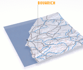 Places with similar names to Bou Arich, Morocco ::
Disclaimer :: Information on this page comes without warranty of any kind |
||
|
Where is Bou Arich? Elevation and coordinates ::
Latitude (lat): 31°2'0"N Longitude (lon): 9°47'0"W
Elevation (approx.): 231m (map arrows pan, magnifying glasses zoom) |
||
|
Visiting Bou Arich? Hotel/Accommodation ::
Book a hotel in Bou Arich Travel Guide ::
Buy a travel guide for Morocco rental cars ::
car rental offers GPS waypoint ::
download a GPX waypoint (PoI) of Bou Arich for your GPS receiver
|
||