|
search place name
|
||
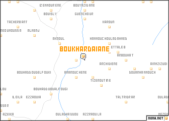
Bou Khardaïane (Taza, Morocco)Bou Khardaïane is a town in the Taza region of Morocco. An overview map of the region around Bou Khardaïane is displayed below.
regional and 3d topo map of Bou Khardaïane, Morocco ::
Bou Khardaïane airports ::
The nearest airport is AHU - Al Hociema Cherif El Idrissi, located 62.2 km north of Bou Khardaïane.
Other airports nearby include MLN - Melilla (107.7 km north east), FEZ - Fez Saiss (131.5 km south west), OUD - Oujda Angads (174.4 km east), TTU - Tetouan Saniat Rmel (174.8 km north west), Nearby towns ::
Ichnouffene (1.5km west) //
Amarouchene (4.0km south) //
Siwane (4.0km south) //
Sidi Mohand et Taleb (4.9km east) //
Archidiene (4.9km east) //
Hammouch Oulad Ahmed (5.9km north east) //
Aknoul (5.9km north west) //
Tizeroutine (6.3km south east) //
Ez Zaouia (6.4km east) //
Karoun (8.7km north east) //
Bou Hadduod al Fougi (9.6km south west) //
[all distances 'as the bird flies' and approximate] 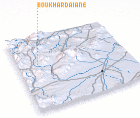 Places with similar names to Bou Khardaïane, Morocco :: Disclaimer :: Information on this page comes without warranty of any kind |
||
|
Where is Bou Khardaïane? Elevation and coordinates ::
Latitude (lat): 34°37'0"N Longitude (lon): 3°49'0"W
Elevation (approx.): 1104m (map arrows pan, magnifying glasses zoom) |
||
|
Visiting Bou Khardaïane? Hotel/Accommodation ::
Book a hotel in Bou Khardaïane Travel Guide ::
Buy a travel guide for Morocco rental cars ::
car rental offers GPS waypoint ::
download a GPX waypoint (PoI) of Bou Khardaïane for your GPS receiver
|
||