|
search place name
|
||
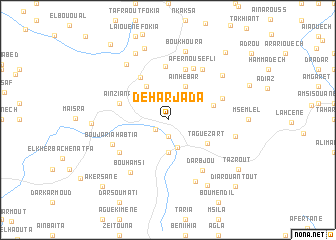
Dehar Jaʼda (Larache, Morocco)Dehar Jaʼda is a town in the Larache region of Morocco. An overview map of the region around Dehar Jaʼda is displayed below.
regional and 3d topo map of Dehar Jaʼda, Morocco ::
Dehar Jaʼda airports ::
The nearest airport is TTU - Tetouan Saniat Rmel, located 41.0 km north east of Dehar Jaʼda.
Other airports nearby include TNG - Tanger Ibn Batouta (53.0 km north west), GIB - Gibraltar (95.7 km north), NNA - Kentira Kenitra (144.1 km south west), MEK - Meknes Bassatine (159.7 km south), Nearby towns ::
Souk Khemis des Beni Arouss (1.6km south west) //
Mejmoulâ (1.8km south) //
Bouzouhri (3.2km south) //
Oum er Râs (3.7km south) //
Aïn Hebâr (4.1km north east) //
Maïzine (3.7km north west) //
Bou Amar (4.2km north west) //
Taguezart (4.5km south east) //
El Harech (4.4km east) //
Merj Hammoud (5.4km north west) //
Aïn Ziana (4.8km north west) //
Tamezguida (5.8km north) //
Tardane (6.0km north) //
Afernou Sefli (6.2km north) //
Dar el Haït (5.5km north east) //
Er Remla (5.8km south west) //
Afernoû el Fouki (6.4km north east) //
Boujaria Habtia (5.8km south west) //
Dar Bjou (6.5km south east) //
Bou Hamsi (6.8km south west) //
Ed Dechiyar (7.3km south) //
Arhil (6.4km east) //
Afkir (7.3km north west) //
Bou Khoura (7.8km north) //
Tazia (7.0km north east) //
Laïouene Seflia (8.0km north) //
El Aïoun Foukia (8.3km north) //
Tazglout (8.1km south east) //
Aïn el Hedid (7.0km west) //
[all distances 'as the bird flies' and approximate]  Places with similar names to Dehar Jaʼda, Morocco :: Disclaimer :: Information on this page comes without warranty of any kind |
||
|
Where is Dehar Jaʼda? Elevation and coordinates ::
Latitude (lat): 35°18'59"N Longitude (lon): 5°37'3"W
Elevation (approx.): 232m (map arrows pan, magnifying glasses zoom) |
||
|
Visiting Dehar Jaʼda? Hotel/Accommodation ::
Book a hotel in Dehar Jaʼda Travel Guide ::
Buy a travel guide for Morocco rental cars ::
car rental offers GPS waypoint ::
download a GPX waypoint (PoI) of Dehar Jaʼda for your GPS receiver
|
||