|
search place name
|
||
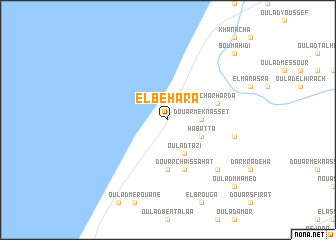
El Behara (Kenitra, Morocco)El Behara is a town in the Kenitra region of Morocco. An overview map of the region around El Behara is displayed below.
regional and 3d topo map of El Behara, Morocco ::
El Behara airports ::
The nearest airport is NNA - Kentira Kenitra, located 46.9 km south west of El Behara.
Other airports nearby include RBA - Rabat Sale (77.8 km south west), MEK - Meknes Bassatine (119.8 km south east), TNG - Tanger Ibn Batouta (123.3 km north), TTU - Tetouan Saniat Rmel (140.0 km north east), Nearby towns ::
Douar Meknasset (3.0km east) //
Habatta (3.6km south east) //
Oulad Tazi (4.0km south) //
Dar Remiki (5.6km south) //
Douar Chaïssahat (5.8km south) //
Charharda (4.9km east) //
Douar Tebandat (6.4km east) //
Oulad Bekhachou (7.2km south east) //
Oulad Mhamed (9.6km south east) //
Boumahidi (9.6km north east) //
El Amiriine (9.6km north east) //
[all distances 'as the bird flies' and approximate] 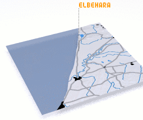 Places with similar names to El Behara, Morocco ::
Disclaimer :: Information on this page comes without warranty of any kind |
||
|
Where is El Behara? Elevation and coordinates ::
Latitude (lat): 34°41'0"N Longitude (lon): 6°23'0"W
Elevation (approx.): 18m (map arrows pan, magnifying glasses zoom) |
||
|
Visiting El Behara? Hotel/Accommodation ::
Book a hotel in El Behara Travel Guide ::
Buy a travel guide for Morocco rental cars ::
car rental offers GPS waypoint ::
download a GPX waypoint (PoI) of El Behara for your GPS receiver
|
||