|
search place name
|
||
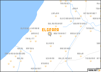
El Grara (Tiznit, Morocco)El Grara is a town in the Tiznit region of Morocco. An overview map of the region around El Grara is displayed below.
regional and 3d topo map of El Grara, Morocco ::
El Grara airports ::
The nearest airport is AGA - Agadir Inezgane, located 61.1 km north of El Grara.
Other airports nearby include TTA - Tan Tan Plage Blanche (209.5 km south west), RAK - Marrakech Menara (252.7 km north east), Nearby towns ::
El Mers (3.7km south) //
Bou Tammaït (3.2km east) //
Oulad Noumer (4.0km north east) //
Draïmiz (4.8km west) //
El Ksbat (5.2km west) //
El Feïd el Khnabib (6.7km west) //
Timslitt (6.7km west) //
Larjam (7.6km north) //
Amesrhar (7.4km south east) //
Anfoud (8.5km south west) //
El Azib Oumerzgoun (8.5km north east) //
[all distances 'as the bird flies' and approximate] 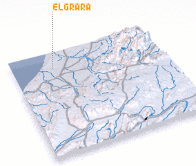 Places with similar names to El Grara, Morocco ::
// El Cruero (CO)
// El Curari (VE)
// El Curari (VE)
// El Curarí (VE)
// El Curarí (VE)
// El Groura (MA)
// El Cororo (HN)
// El Garrora (ET)
// El Guerara (DZ)
Disclaimer :: Information on this page comes without warranty of any kind |
||
|
Where is El Grara? Elevation and coordinates ::
Latitude (lat): 29°51'0"N Longitude (lon): 9°43'0"W
Elevation (approx.): 124m (map arrows pan, magnifying glasses zoom) |
||
|
Visiting El Grara? Hotel/Accommodation ::
Book a hotel in El Grara Travel Guide ::
Buy a travel guide for Morocco rental cars ::
car rental offers GPS waypoint ::
download a GPX waypoint (PoI) of El Grara for your GPS receiver
|
||