|
search place name
|
||
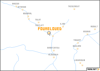
Foum el Oued (Ouarzazate, Morocco)Foum el Oued is a town in the Ouarzazate region of Morocco. An overview map of the region around Foum el Oued is displayed below.
regional and 3d topo map of Foum el Oued, Morocco ::
Foum el Oued airports ::
The nearest airport is OZZ - Ouarzazate, located 65.5 km north of Foum el Oued.
Other airports nearby include RAK - Marrakech Menara (179.9 km north west), Nearby towns ::
Aït Hammoudou (0.9km east) //
Tastlift (4.3km north west) //
Aïn Aït Zatou (5.8km south) //
Iliah (5.4km north east) //
Talat (6.2km north west) //
Alougoum (8.3km south) //
Aït Mrabet (9.4km north west) //
Bou Arial (10.1km north west) //
[all distances 'as the bird flies' and approximate] 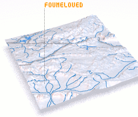 Places with similar names to Foum el Oued, Morocco ::
// Fombellida (ES)
// Fombellida (ES)
// Fuembellida (ES)
// Phumĭ Laô Tiĕ (KH)
// Phumĭ Laô Tiĕ (KH)
// Phumĭ L'iĕt (KH)
// Phumĭ Lôt (KH)
// Phumĭ O Lĕt (KH)
// Fomolodou (GN)
Disclaimer :: Information on this page comes without warranty of any kind |
||
|
Where is Foum el Oued? Elevation and coordinates ::
Latitude (lat): 30°21'5"N Longitude (lon): 6°50'34"W
Elevation (approx.): 869m (map arrows pan, magnifying glasses zoom) |
||
|
Visiting Foum el Oued? Hotel/Accommodation ::
Book a hotel in Foum el Oued Travel Guide ::
Buy a travel guide for Morocco rental cars ::
car rental offers GPS waypoint ::
download a GPX waypoint (PoI) of Foum el Oued for your GPS receiver
|
||