|
search place name
|
||
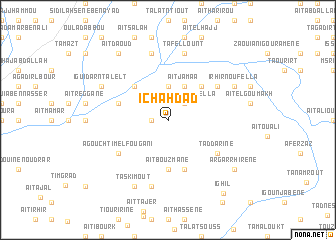
Ichahdad (Taroudannt, Morocco)Ichahdad is a town in the Taroudannt region of Morocco. An overview map of the region around Ichahdad is displayed below.
regional and 3d topo map of Ichahdad, Morocco ::
Ichahdad airports ::
The nearest airport is AGA - Agadir Inezgane, located 114.8 km west of Ichahdad.
Other airports nearby include RAK - Marrakech Menara (121.3 km north), OZZ - Ouarzazate (146.1 km east), Nearby towns ::
Dou Imoula (1.6km west) //
Iferkane nʼOufella (2.4km north east) //
Iferkane nʼIzder (3.7km north) //
Aït Jamaa (4.0km north east) //
Igoudar (4.9km north west) //
Aït Guerri (4.9km north east) //
Aït Bouzmane (5.6km south) //
Oulad Abbou (5.1km west) //
Aït Lahsene Ou Brahim (5.1km west) //
Tigounatine (5.8km south) //
Agadir nʼ Iznaguene (6.1km north east) //
Taddarine (6.1km south east) //
Agouchtim el Fougani (6.1km south west) //
Tasgount (7.6km south) //
Aït Hamid (7.6km north) //
Tafellount (7.6km north) //
Chebika (7.4km north west) //
Iguidar nʼTalelt (7.4km north west) //
Irhir nʼOufella (7.4km north east) //
Taskimout (8.1km south west) //
Aït Daoud (8.8km north west) //
Argar Rhirene (8.5km south east) //
Ighil (9.8km south east) //
[all distances 'as the bird flies' and approximate]  Places with similar names to Ichahdad, Morocco ::
// Ichetdi (RU)
Disclaimer :: Information on this page comes without warranty of any kind |
||
|
Where is Ichahdad? Elevation and coordinates ::
Latitude (lat): 30°33'0"N Longitude (lon): 8°22'0"W
Elevation (approx.): 587m (map arrows pan, magnifying glasses zoom) |
||
|
Visiting Ichahdad? Hotel/Accommodation ::
Book a hotel in Ichahdad Travel Guide ::
Buy a travel guide for Morocco rental cars ::
car rental offers GPS waypoint ::
download a GPX waypoint (PoI) of Ichahdad for your GPS receiver
|
||