|
search place name
|
||
Kanouat (Tanger, Morocco)Kanouat is a town in the Tanger region of Morocco. An overview map of the region around Kanouat is displayed below.
regional and 3d topo map of Kanouat, Morocco ::

Kanouat airports ::
The nearest airport is TNG - Tanger Ibn Batouta, located 7.2 km north of Kanouat.
Other airports nearby include TTU - Tetouan Saniat Rmel (54.1 km east), GIB - Gibraltar (74.3 km north east), XRY - Jerez (120.8 km north), NNA - Kentira Kenitra (163.7 km south west), Nearby towns ::
Daidatz (0.7km north west) //
Dar Zhirou (3.5km north east) //
Gzennaïa (4.6km north) //
Chouikrech (4.9km north east) //
Hajra en Nhal (5.7km south) //
Seguedla (5.5km south east) //
Hajreien (6.3km north west) //
Badriouene (6.2km north east) //
Bougdour (5.6km east) //
Aïn Bellout (5.6km east) //
Haouara (5.9km south west) //
Sidi Hassaïn (6.0km north east) //
Mediar (7.4km south) //
Boukhalef (7.8km north) //
Dar Sultan (8.0km north) //
Aïn Dalia Kebira (6.6km east) //
Khendek Zarzour (7.4km east) //
Kahaoucha (9.0km south) //
Oulad Ziane (7.8km south east) //
El Mers (8.7km south west) //
Beni Touzine (10.7km north east) //
Beni Saïd (10.7km north east) //
[all distances 'as the bird flies' and approximate] 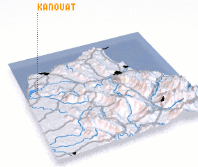 Places with similar names to Kanouat, Morocco ::
Disclaimer :: Information on this page comes without warranty of any kind |
||
|
Where is Kanouat? Elevation and coordinates ::
Latitude (lat): 35°39'44"N Longitude (lon): 5°54'41"W
Elevation (approx.): 9m (map arrows pan, magnifying glasses zoom) |
||
|
Visiting Kanouat? Hotel/Accommodation ::
Book a hotel in Kanouat Travel Guide ::
Buy a travel guide for Morocco rental cars ::
car rental offers GPS waypoint ::
download a GPX waypoint (PoI) of Kanouat for your GPS receiver
|
||