|
search place name
|
||
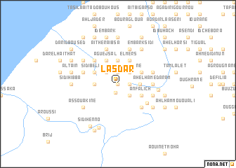
Lasdar (Tiznit, Morocco)Lasdar is a town in the Tiznit region of Morocco. An overview map of the region around Lasdar is displayed below.
regional and 3d topo map of Lasdar, Morocco ::
Lasdar airports ::
The nearest airport is TTA - Tan Tan Plage Blanche, located 119.4 km south west of Lasdar.
Other airports nearby include AGA - Agadir Inezgane (151.8 km north east), Nearby towns ::
Sidi Mansour (0.0km north) //
Aoutlaouk (1.4km south) //
Boul Nouit (1.6km east) //
Bouchma (1.6km east) //
Agroun Moblar (1.9km north) //
Ait Buhucu (2.5km south east) //
Hamed Ou Mohand (2.5km north east) //
Ahl Salane (2.5km north east) //
Sidi Brahim (2.5km north west) //
Et Tlêta Sboûya (3.1km east) //
Tikensar (3.7km north) //
Sidi Mohammed Gout (3.2km west) //
El Mers (4.0km north east) //
Anfalich (3.7km south east) //
Talah Ou Abbou (3.7km north east) //
Aguejsal (4.0km north west) //
Houafi (4.0km north west) //
Tilisas (4.0km north west) //
Aït Slimane (3.7km north west) //
Sidi Belaïd (3.7km north west) //
Mulquens (4.9km south east) //
Aguechgal (4.9km north west) //
Tamassoukt (5.1km south east) //
Ahel Hamed Aram (4.9km east) //
Tifán (4.9km east) //
Azad (4.9km east) //
Asbaro (5.8km north) //
Aït Ben Noumene (5.2km east) //
Ahl Embark Housseïn (5.2km east) //
[all distances 'as the bird flies' and approximate] 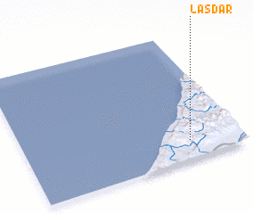 Places with similar names to Lasdar, Morocco ::
Disclaimer :: Information on this page comes without warranty of any kind |
||
|
Where is Lasdar? Elevation and coordinates ::
Latitude (lat): 29°9'0"N Longitude (lon): 10°14'0"W
Elevation (approx.): 332m (map arrows pan, magnifying glasses zoom) |
||
|
Visiting Lasdar? Hotel/Accommodation ::
Book a hotel in Lasdar Travel Guide ::
Buy a travel guide for Morocco rental cars ::
car rental offers GPS waypoint ::
download a GPX waypoint (PoI) of Lasdar for your GPS receiver
|
||