|
search place name
|
||
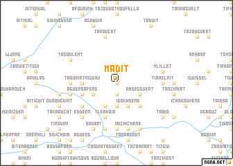
Madit (Taroudannt, Morocco)Madit is a town in the Taroudannt region of Morocco. An overview map of the region around Madit is displayed below.
regional and 3d topo map of Madit, Morocco ::
Madit airports ::
The nearest airport is RAK - Marrakech Menara, located 91.4 km north of Madit.
Other airports nearby include OZZ - Ouarzazate (113.6 km east), AGA - Agadir Inezgane (147.2 km west), Nearby towns ::
Talemsaout (NaNkm north) //
Amznes (1.9km south) //
Irhil (1.9km north) //
Tagant (3.7km south) //
Idakhsene (4.0km south east) //
Idoukaln (3.7km south east) //
Amsegguert (3.7km south east) //
Tameddenst (3.7km south east) //
Bou Ou Mazir (4.0km south west) //
Arhbalou (3.7km south west) //
Agouni Ba Messaoud (3.7km south west) //
Taddert (4.9km south east) //
Taourirt nʼIguidi (4.8km west) //
Aguersafene (5.1km west) //
Tlemkaïa (5.8km south) //
Tatkaracht (5.8km south) //
Zaouia Babelli (6.0km south west) //
Ihouziine (6.0km south west) //
Adroug (7.4km south) //
Tinmelrit (6.4km east) //
Tanfist (6.4km west) //
Ibichichene (7.6km south) //
Anmid (7.6km south) //
Mlillet (6.6km east) //
Tazouggart (6.6km west) //
Takoucht (7.6km north) //
Eddern (7.3km south west) //
Toug el Khir (8.1km south east) //
Aoufour (8.1km south east) //
[all distances 'as the bird flies' and approximate] 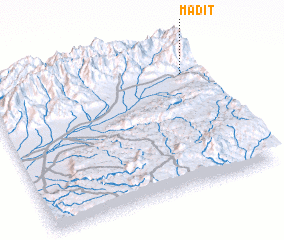 Places with similar names to Madit, Morocco ::
Disclaimer :: Information on this page comes without warranty of any kind |
||
|
Where is Madit? Elevation and coordinates ::
Latitude (lat): 30°47'0"N Longitude (lon): 8°5'0"W
Elevation (approx.): 1335m (map arrows pan, magnifying glasses zoom) |
||
|
Visiting Madit? Hotel/Accommodation ::
Book a hotel in Madit Travel Guide ::
Buy a travel guide for Morocco rental cars ::
car rental offers GPS waypoint ::
download a GPX waypoint (PoI) of Madit for your GPS receiver
|
||