|
search place name
|
||
Mezdrha es Souk (Fès, Morocco)Mezdrha es Souk is a town in the Fès region of Morocco. An overview map of the region around Mezdrha es Souk is displayed below.
regional and 3d topo map of Mezdrha es Souk, Morocco ::

Mezdrha es Souk airports ::
The nearest airport is FEZ - Fez Saiss, located 26.7 km north west of Mezdrha es Souk.
Other airports nearby include MEK - Meknes Bassatine (72.9 km west), AHU - Al Hociema Cherif El Idrissi (173.4 km north east), NNA - Kentira Kenitra (180.7 km west), TTU - Tetouan Saniat Rmel (206.2 km north), Nearby towns ::
Moujou (2.4km north west) //
Aït Haj Ali (3.7km south) //
Aït Brahim (3.1km west) //
Aït Belaïd (5.6km south) //
Dehar al Qarroub (5.0km east) //
Dahar el Kharroub (5.0km east) //
Aït Taleb (5.0km west) //
Mezdgha Souq (5.0km east) //
Mechla (5.9km south east) //
Zgane (6.4km south east) //
Zaouia Sidi Lahsene (6.4km east) //
Aït Bel Hassene (7.6km south) //
Jenane Sidi Amer (6.4km west) //
Iaouine (6.4km west) //
Tajanat (8.0km south west) //
[all distances 'as the bird flies' and approximate] 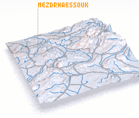 Places with similar names to Mezdrha es Souk, Morocco :: Disclaimer :: Information on this page comes without warranty of any kind |
||
|
Where is Mezdrha es Souk? Elevation and coordinates ::
Latitude (lat): 33°48'0"N Longitude (lon): 4°44'0"W
Elevation (approx.): 935m (map arrows pan, magnifying glasses zoom) |
||
|
Visiting Mezdrha es Souk? Hotel/Accommodation ::
Book a hotel in Mezdrha es Souk Travel Guide ::
Buy a travel guide for Morocco rental cars ::
car rental offers GPS waypoint ::
download a GPX waypoint (PoI) of Mezdrha es Souk for your GPS receiver
|
||