|
search place name
|
||
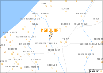
Mgrounat (Tiznit, Morocco)Mgrounat is a town in the Tiznit region of Morocco. An overview map of the region around Mgrounat is displayed below.
regional and 3d topo map of Mgrounat, Morocco ::
Mgrounat airports ::
The nearest airport is AGA - Agadir Inezgane, located 74.8 km north of Mgrounat.
Other airports nearby include TTA - Tan Tan Plage Blanche (197.0 km south west), RAK - Marrakech Menara (265.6 km north east), Nearby towns ::
Tadouart (0.8km south west) //
Dou Tourga (3.5km south east) //
Atbane (3.5km north east) //
Atbane (3.5km north east) //
Igourar nʼAït Mʼhamed (3.8km south west) //
Tiznit (4.9km east) //
Tamdroust (5.9km south) //
Dchaïra (5.9km north east) //
Aglou (6.3km north west) //
Anfoud (7.6km north) //
Igourar nʼ Sidi Abd er Rahmane (7.3km west) //
Id Aïssa (7.5km west) //
Iderk (9.0km north west) //
Zaouia Sidi Ouaggag (8.7km north west) //
Sidi Daoud (9.6km south west) //
[all distances 'as the bird flies' and approximate]  Places with similar names to Mgrounat, Morocco ::
// Mó Grande (PT)
// Mākranda (BD)
// Mākrāund (BD)
// Mucurandá (VE)
// Maqrīnāt (SY)
// Muqrīnāt (SY)
// Magranetʼi (GE)
// Mai Cornet (BE)
Disclaimer :: Information on this page comes without warranty of any kind |
||
|
Where is Mgrounat? Elevation and coordinates ::
Latitude (lat): 29°44'0"N Longitude (lon): 9°45'50"W
Elevation (approx.): 187m (map arrows pan, magnifying glasses zoom) |
||
|
Visiting Mgrounat? Hotel/Accommodation ::
Book a hotel in Mgrounat Travel Guide ::
Buy a travel guide for Morocco rental cars ::
car rental offers GPS waypoint ::
download a GPX waypoint (PoI) of Mgrounat for your GPS receiver
|
||