|
search place name
|
||
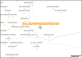
Oulad Hammou Ou Moussa (Taza, Morocco)Oulad Hammou Ou Moussa is a town in the Taza region of Morocco. An overview map of the region around Oulad Hammou Ou Moussa is displayed below.
regional and 3d topo map of Oulad Hammou Ou Moussa, Morocco ::
Oulad Hammou Ou Moussa airports ::
The nearest airport is AHU - Al Hociema Cherif El Idrissi, located 98.0 km north of Oulad Hammou Ou Moussa.
Other airports nearby include FEZ - Fez Saiss (123.5 km west), MLN - Melilla (129.1 km north east), MEK - Meknes Bassatine (172.4 km west), OUD - Oujda Angads (173.2 km east), Nearby towns ::
Msoun (4.0km south) //
Oulad el Haj (4.8km south east) //
Ouled Aïssa (5.0km west) //
Mzarcha (5.0km west) //
Mohand Abd el Jellil (5.9km south west) //
El Melloukine (7.6km south) //
Ben Zarga (7.2km north west) //
Cheïkh Ben Amar (9.6km north west) //
Oulad el Adel (9.6km north west) //
[all distances 'as the bird flies' and approximate] 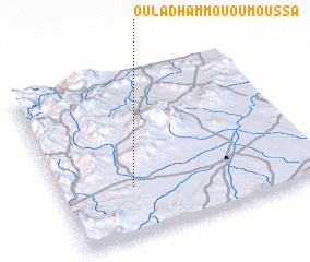 Places with similar names to Oulad Hammou Ou Moussa, Morocco :: Disclaimer :: Information on this page comes without warranty of any kind |
||
|
Where is Oulad Hammou Ou Moussa? Elevation and coordinates ::
Latitude (lat): 34°18'0"N Longitude (lon): 3°43'0"W
Elevation (approx.): 554m (map arrows pan, magnifying glasses zoom) |
||
|
Visiting Oulad Hammou Ou Moussa? Hotel/Accommodation ::
Book a hotel in Oulad Hammou Ou Moussa Travel Guide ::
Buy a travel guide for Morocco rental cars ::
car rental offers GPS waypoint ::
download a GPX waypoint (PoI) of Oulad Hammou Ou Moussa for your GPS receiver
|
||