|
search place name
|
||
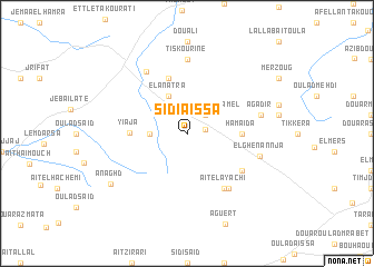
Sidi Aïssa (Essaouira, Morocco)Sidi Aïssa is a town in the Essaouira region of Morocco. An overview map of the region around Sidi Aïssa is displayed below.
regional and 3d topo map of Sidi Aïssa, Morocco ::
Sidi Aïssa airports ::
The nearest airport is RAK - Marrakech Menara, located 123.5 km east of Sidi Aïssa.
Other airports nearby include AGA - Agadir Inezgane (147.6 km south), CMN - Casablanca Mohammed V Intl (247.0 km north east), Nearby towns ::
El Arba des Naïrat (1.6km east) //
Mohammed Bel Kamel (2.4km north east) //
Aït el Hajj Messaoud (3.2km west) //
El Anatra (4.0km north west) //
Hamaïda (4.7km east) //
Yiaja (4.9km west) //
El Hamouinat (5.8km north) //
Ahmed Ben Jilali Fejrih (6.0km south east) //
Aït el Ayachi (6.4km south east) //
Moulay Tahar Ben Driss (6.6km south east) //
Zaouia Sidi Hamou Ben Hamida (7.1km north west) //
Tiskouríne (7.4km north) //
Agadir (6.6km east) //
El Ghenannja (6.6km east) //
Anaghd (8.3km south west) //
[all distances 'as the bird flies' and approximate] 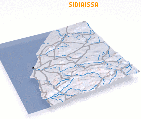 Places with similar names to Sidi Aïssa, Morocco ::
// Sadies (MA)
// Sidi Aïssa (MA)
// Sidi Aïssa (MA)
// Sidi Aïssa (MA)
// Sidi Aïssa (MA)
// Seytas (AZ)
// Satsa (MM)
// Satse (MM)
// Setzaw (MM)
// Setse (MM)
Disclaimer :: Information on this page comes without warranty of any kind |
||
|
Where is Sidi Aïssa? Elevation and coordinates ::
Latitude (lat): 31°42'0"N Longitude (lon): 9°20'0"W
Elevation (approx.): 421m (map arrows pan, magnifying glasses zoom) |
||
|
Visiting Sidi Aïssa? Hotel/Accommodation ::
Book a hotel in Sidi Aïssa Travel Guide ::
Buy a travel guide for Morocco rental cars ::
car rental offers GPS waypoint ::
download a GPX waypoint (PoI) of Sidi Aïssa for your GPS receiver
|
||