|
search place name
|
||
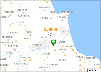
Souani (Tétouan, Morocco)Souani is a town in the Tétouan region of Morocco. An overview map of the region around Souani is displayed below.
regional and 3d topo map of Souani, Morocco ::
Souani airports ::
The nearest airport is TTU - Tetouan Saniat Rmel, located 2.4 km south east of Souani.
Other airports nearby include TNG - Tanger Ibn Batouta (54.5 km west), GIB - Gibraltar (59.7 km north), AGP - Malaga (139.5 km north east), XRY - Jerez (141.6 km north west), Nearby towns ::
El Malaliyine (2.0km north west) //
Torre (2.3km south west) //
Bou Hjiyer (3.0km north west) //
Dar Alalou (5.4km south) //
Knikra (4.9km south east) //
Ghniouete (5.9km north) //
Martil (4.9km east) //
Mouklata (6.1km south) //
Tétouan (6.0km south west) //
El Groura (6.9km north east) //
Talmadi (7.1km south east) //
Siadar (6.3km west) //
Kitane (7.8km south) //
Mʼdik (8.0km north) //
Beni Salah (8.3km south) //
Mousiti (8.3km south east) //
Semsa (7.3km west) //
El Maassem (8.2km south east) //
Ras el Aswad (9.3km north east) //
[all distances 'as the bird flies' and approximate]  Places with similar names to Souani, Morocco ::
Disclaimer :: Information on this page comes without warranty of any kind |
||
|
Where is Souani? Elevation and coordinates ::
Latitude (lat): 35°36'49"N Longitude (lon): 5°19'51"W
Elevation (approx.): 13m (map arrows pan, magnifying glasses zoom) |
||
|
Visiting Souani? Hotel/Accommodation ::
Book a hotel in Souani Travel Guide ::
Buy a travel guide for Morocco rental cars ::
car rental offers GPS waypoint ::
download a GPX waypoint (PoI) of Souani for your GPS receiver
|
||