|
search place name
|
||
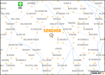
Sraghna (Marrakech, Morocco)Sraghna is a town in the Marrakech region of Morocco. An overview map of the region around Sraghna is displayed below.
regional and 3d topo map of Sraghna, Morocco ::
Sraghna airports ::
The nearest airport is RAK - Marrakech Menara, located 15.4 km north west of Sraghna.
Other airports nearby include OZZ - Ouarzazate (115.7 km south east), AGA - Agadir Inezgane (197.8 km south west), CMN - Casablanca Mohammed V Intl (209.6 km north), Nearby towns ::
Aït Hamid (1.6km east) //
Bou Azza (2.4km south east) //
Châba (3.0km north east) //
Segraga (3.7km north) //
Moulay Cherif (4.0km north east) //
El Aggada (3.7km south east) //
Aït Amara (3.7km north east) //
El Harkat (4.8km north west) //
Loukid (5.4km south) //
El Mers (5.6km south) //
Aïn Jdid (5.8km north) //
El Rhechat (5.1km west) //
Akhatar (5.1km east) //
Sraïri (5.1km east) //
Touggana (6.4km north west) //
Heddad (6.3km east) //
Imoudaïn (7.4km south) //
Bou Lanouar (7.4km north) //
Srarhna (6.6km east) //
Aït Bou Zguia (6.6km east) //
Bakader (7.6km south) //
Talbarat (7.6km north) //
Berrada (7.6km north) //
Tougouana (7.6km south) //
Oulad Mansour (6.6km west) //
El Gouassem (7.3km north west) //
Taddert (7.3km south west) //
Fourou (7.3km north east) //
Aït Kerroum (7.3km south east) //
[all distances 'as the bird flies' and approximate]  Places with similar names to Sraghna, Morocco ::
Disclaimer :: Information on this page comes without warranty of any kind |
||
|
Where is Sraghna? Elevation and coordinates ::
Latitude (lat): 31°30'0"N Longitude (lon): 7°56'0"W
Elevation (approx.): 605m (map arrows pan, magnifying glasses zoom) |
||
|
Visiting Sraghna? Hotel/Accommodation ::
Book a hotel in Sraghna Travel Guide ::
Buy a travel guide for Morocco rental cars ::
car rental offers GPS waypoint ::
download a GPX waypoint (PoI) of Sraghna for your GPS receiver
|
||