|
search place name
|
||
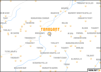
Tamadant (Taroudannt, Morocco)Tamadant is a town in the Taroudannt region of Morocco. An overview map of the region around Tamadant is displayed below.
regional and 3d topo map of Tamadant, Morocco ::
Tamadant airports ::
The nearest airport is AGA - Agadir Inezgane, located 50.7 km south west of Tamadant.
Other airports nearby include RAK - Marrakech Menara (147.4 km north east), Nearby towns ::
Agouni (2.4km north east) //
Amegdoul (3.2km west) //
Tamzaourt (3.2km west) //
Tinileft (4.0km south east) //
Aoujou (3.7km north west) //
Bougadrour (3.7km north east) //
Bigoudine (4.9km north west) //
Ouaoussekht (5.8km south) //
Tirkou (6.4km south west) //
Agadir Imouzgaoun (6.4km north west) //
Aglou (6.0km north east) //
Ida Ou Kess Oufella (7.4km south) //
Iferd (6.6km east) //
Tassademt (6.6km west) //
Mezzint (7.6km north) //
Aguenza (7.6km north) //
Tiguert (7.3km south east) //
Timdermit (7.4km south west) //
Tazarine (7.4km north west) //
Tanamert (8.1km south west) //
Iggounane (7.4km south east) //
Sanaga (7.4km north east) //
Loummih (7.6km south east) //
Sinit (8.5km north west) //
[all distances 'as the bird flies' and approximate]  Places with similar names to Tamadant, Morocco ::
// Tambatinndi (ML)
// Ðiêm Ðiên (3) (VN)
Disclaimer :: Information on this page comes without warranty of any kind |
||
|
Where is Tamadant? Elevation and coordinates ::
Latitude (lat): 30°42'0"N Longitude (lon): 9°10'0"W
Elevation (approx.): 959m (map arrows pan, magnifying glasses zoom) |
||
|
Visiting Tamadant? Hotel/Accommodation ::
Book a hotel in Tamadant Travel Guide ::
Buy a travel guide for Morocco rental cars ::
car rental offers GPS waypoint ::
download a GPX waypoint (PoI) of Tamadant for your GPS receiver
|
||