|
search place name
|
||
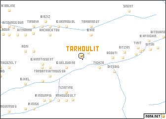
Tarhoulit (Azilal, Morocco)Tarhoulit is a town in the Azilal region of Morocco. An overview map of the region around Tarhoulit is displayed below.
regional and 3d topo map of Tarhoulit, Morocco ::
Tarhoulit airports ::
The nearest airport is OZZ - Ouarzazate, located 84.2 km south west of Tarhoulit.
Other airports nearby include RAK - Marrakech Menara (141.1 km west), CMN - Casablanca Mohammed V Intl (215.7 km north west), Nearby towns ::
Imi nʼTalat (1.8km north east) //
Tighza (3.7km south east) //
Iguelouane (3.7km south west) //
Ighir (5.8km north) //
Agouti (5.8km east) //
Aït Saʼid (6.6km south east) //
Tarhia (6.6km west) //
Assamer (6.6km west) //
Tamarnout (7.6km north) //
Tiziatine (8.1km south west) //
Taouja (8.1km north west) //
Klabo (8.1km north west) //
Iguer nʼOual (8.1km north west) //
Tarbat nʼAït Moussa (7.3km south west) //
Irboula (7.3km south west) //
Ismig (8.8km north west) //
Amchachtou (8.4km north west) //
Taouriat (9.7km north west) //
Iba‘ziz (11.2km north west) //
[all distances 'as the bird flies' and approximate] 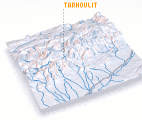 Places with similar names to Tarhoulit, Morocco ::
Disclaimer :: Information on this page comes without warranty of any kind |
||
|
Where is Tarhoulit? Elevation and coordinates ::
Latitude (lat): 31°38'0"N Longitude (lon): 6°33'0"W
Elevation (approx.): 1568m (map arrows pan, magnifying glasses zoom) |
||
|
Visiting Tarhoulit? Hotel/Accommodation ::
Book a hotel in Tarhoulit Travel Guide ::
Buy a travel guide for Morocco rental cars ::
car rental offers GPS waypoint ::
download a GPX waypoint (PoI) of Tarhoulit for your GPS receiver
|
||