|
search place name
|
||
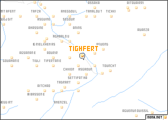
Tighfert (Marrakech, Morocco)Tighfert is a town in the Marrakech region of Morocco. An overview map of the region around Tighfert is displayed below.
regional and 3d topo map of Tighfert, Morocco ::
Tighfert airports ::
The nearest airport is RAK - Marrakech Menara, located 50.6 km north west of Tighfert.
Other airports nearby include OZZ - Ouarzazate (82.5 km south east), AGA - Agadir Inezgane (202.8 km south west), Nearby towns ::
Ifgaïne (1.7km south west) //
Ouigrane (2.5km south east) //
Anammer (2.6km north east) //
Tadmenkal (2.7km west) //
Asgaour (3.2km south) //
Irghaf (3.6km north west) //
Chiker (4.2km south west) //
Aguerd (4.4km north east) //
Amlouggui (4.6km south east) //
Setti Fatma (5.2km south) //
Igrif Foudene (5.0km north west) //
Anins (6.2km north) //
Tourcht (5.6km south east) //
Aghbalou (6.0km north west) //
Aourir (5.9km west) //
Tifertane (6.0km west) //
Tamatert (7.0km south) //
Tadrart (7.1km south west) //
Tiourdiou (8.1km south west) //
Segour (8.4km north) //
Igri el Khemas (7.8km west) //
Ighir el Mizeb (8.6km north west) //
Taourirt Izammer (8.6km north west) //
Aguerd nʼOurtane (9.0km south west) //
Tamzerdirt (9.9km north west) //
Timichchi (10.1km south west) //
Aït Châo (10.1km south west) //
Asguine (10.9km north west) //
[all distances 'as the bird flies' and approximate] 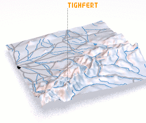 Places with similar names to Tighfert, Morocco ::
// Tafoughart (DZ)
Disclaimer :: Information on this page comes without warranty of any kind |
||
|
Where is Tighfert? Elevation and coordinates ::
Latitude (lat): 31°15'43"N Longitude (lon): 7°41'18"W
Elevation (approx.): 1620m (map arrows pan, magnifying glasses zoom) |
||
|
Visiting Tighfert? Hotel/Accommodation ::
Book a hotel in Tighfert Travel Guide ::
Buy a travel guide for Morocco rental cars ::
car rental offers GPS waypoint ::
download a GPX waypoint (PoI) of Tighfert for your GPS receiver
|
||