|
search place name
|
||
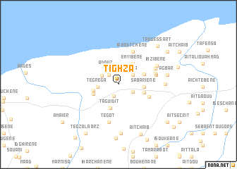
Tighzâ (Al Hoceïma, Morocco)Tighzâ is a town in the Al Hoceïma region of Morocco. An overview map of the region around Tighzâ is displayed below.
regional and 3d topo map of Tighzâ, Morocco ::
Tighzâ airports ::
The nearest airport is AHU - Al Hociema Cherif El Idrissi, located 28.7 km east of Tighzâ.
Other airports nearby include MLN - Melilla (109.9 km east), TTU - Tetouan Saniat Rmel (116.7 km north west), GIB - Gibraltar (154.9 km north west), FEZ - Fez Saiss (155.6 km south west), Nearby towns ::
Tadkant (1.9km south) //
Ihandourene (1.9km north west) //
Rouadi (2.2km south east) //
Maïa (2.4km north east) //
Aït Boûdir (2.6km north west) //
Adoûz (2.9km north west) //
Tegrega (2.7km west) //
Taguidit (3.9km south) //
Emyibene (3.8km north east) //
Boûghamboûb (3.4km west) //
Sabariene (3.4km east) //
Taounîl (3.6km south west) //
L`atmanene (3.6km east) //
Boûchanchet (3.7km north east) //
Ijelloutene (4.4km south east) //
Iaboutchene (5.5km north) //
Tegot (6.0km south) //
Iboutifene (5.1km east) //
Ijandouchene (5.1km east) //
Sâmmar (5.4km north east) //
Imzibene (5.8km north east) //
Gounoûria (6.1km east) //
El Haj Bouker (7.8km south) //
Agbar (6.6km east) //
Bousmada (8.5km south) //
Aït Chaïb (8.4km south) //
Taouessart (8.0km north east) //
Caadoua (8.9km south west) //
Tegza Laarz (8.9km south west) //
[all distances 'as the bird flies' and approximate]  Places with similar names to Tighzâ, Morocco ::
Disclaimer :: Information on this page comes without warranty of any kind |
||
|
Where is Tighzâ? Elevation and coordinates ::
Latitude (lat): 35°9'12"N Longitude (lon): 4°9'13"W
Elevation (approx.): 407m (map arrows pan, magnifying glasses zoom) |
||
|
Visiting Tighzâ? Hotel/Accommodation ::
Book a hotel in Tighzâ Travel Guide ::
Buy a travel guide for Morocco rental cars ::
car rental offers GPS waypoint ::
download a GPX waypoint (PoI) of Tighzâ for your GPS receiver
|
||