|
search place name
|
||
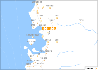
Agopop (Zambales, Philippines)Agopop is a town in the Zambales region of Philippines. An overview map of the region around Agopop is displayed below.
regional and 3d topo map of Agopop, Philippines ::
Agopop airports ::
The nearest airport is BAG - Baguio, located 115.4 km north east of Agopop.
Other airports nearby include MNL - Manila Ninoy Aquino Intl (160.4 km south east), Nearby towns ::
Santa Barbara (1.2km north west) //
Bunga (1.2km north west) //
Masinloc (2.3km west) //
Balugonan (2.5km west) //
Lumboy (2.5km west) //
Matalvi (2.5km west) //
Barco (2.8km south) //
Mapait (3.7km south) //
Tikling (3.7km north west) //
Buri (4.0km south east) //
Bamban (4.6km south) //
San Jose (4.6km south) //
Ubat (4.8km north) //
Santo Rosario (5.7km south) //
Taltal (6.0km north west) //
San Salvador (6.0km west) //
Binabalian (6.3km north west) //
Bani (6.7km north west) //
San Lorenzo (7.1km south) //
Pita (7.2km north east) //
Lauis (7.2km north west) //
Dalolac (7.3km south west) //
Lanot (7.6km north west) //
Titi-on (9.2km south west) //
Babangcal (9.4km north west) //
Catol (9.7km north west) //
[all distances 'as the bird flies' and approximate]  Places with similar names to Agopop, Philippines ::
Disclaimer :: Information on this page comes without warranty of any kind |
||
|
Where is Agopop? Elevation and coordinates ::
Latitude (lat): 15°32'28"N Longitude (lon): 119°58'20"E
Elevation (approx.): 18m (map arrows pan, magnifying glasses zoom) |
||
|
Visiting Agopop? Hotel/Accommodation ::
Book a hotel in Agopop Travel Guide ::
Buy a travel guide for Philippines rental cars ::
car rental offers GPS waypoint ::
download a GPX waypoint (PoI) of Agopop for your GPS receiver
|
||