|
search place name
|
||
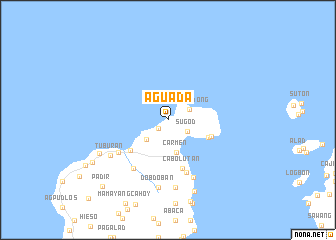
Aguada (Romblon, Philippines)Aguada is a town in the Romblon region of Philippines. An overview map of the region around Aguada is displayed below.
regional and 3d topo map of Aguada, Philippines ::
Aguada airports ::
The nearest airport is KLO - Kalibo, located 111.3 km south of Aguada.
Other airports nearby include SJI - San Jose Antique (209.4 km south), ILO - Iloilo (219.6 km south), MNL - Manila Ninoy Aquino Intl (237.0 km north west), Nearby towns ::
Tambac (1.4km south west) //
Sugod (2.5km south east) //
Dayongdong (2.6km north east) //
Talisay (3.2km south west) //
Carmen (3.7km south) //
Cauayan (4.8km south east) //
Mahabangbaybay (5.1km east) //
Calatrava (5.3km south west) //
Cabolutan (5.7km south) //
Dumayay (6.2km south) //
Canoban (6.5km south west) //
Pagsangahan (6.6km south west) //
Canomiang (7.0km south east) //
Cagbagacay (7.5km south) //
Dobdoban (7.6km south) //
Tuburan (7.4km south west) //
Cagmaya (8.4km south west) //
Daquitdaquit (8.5km south) //
Bangquiling (9.5km south west) //
Padir (10.3km south west) //
Dapdap (12.3km south west) //
[all distances 'as the bird flies' and approximate] 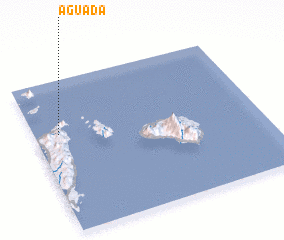 Places with similar names to Aguada, Philippines ::
Disclaimer :: Information on this page comes without warranty of any kind |
||
|
Where is Aguada? Elevation and coordinates ::
Latitude (lat): 12°39'3"N Longitude (lon): 122°6'33"E
Elevation (approx.): 57m (map arrows pan, magnifying glasses zoom) |
||
|
Visiting Aguada? Hotel/Accommodation ::
Book a hotel in Aguada Travel Guide ::
Buy a travel guide for Philippines rental cars ::
car rental offers GPS waypoint ::
download a GPX waypoint (PoI) of Aguada for your GPS receiver
|
||