|
search place name
|
||
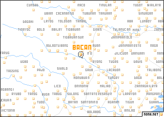
Bacan (Iloilo, Philippines)Bacan is a town in the Iloilo region of Philippines. An overview map of the region around Bacan is displayed below.
regional and 3d topo map of Bacan, Philippines ::
Bacan airports ::
The nearest airport is ILO - Iloilo, located 20.7 km south east of Bacan.
Other airports nearby include BCD - Bacolod (57.2 km south east), SJI - San Jose Antique (59.7 km west), KLO - Kalibo (88.6 km north), NOP - Masbate Mactan Cebu Intl (177.4 km east), Nearby towns ::
Maraguit (1.8km east) //
Ginis Interior (1.8km east) //
Tuy-an (1.8km east) //
Lutac (1.8km east) //
Tupol (1.8km east) //
Ito (1.8km east) //
Pamul-ogan (1.8km east) //
Tenio-an (1.8km east) //
Salacay (1.8km east) //
Guibuangan Tigbauan (1.8km east) //
Li-ong (1.8km east) //
Pongtod (1.8km east) //
Puyas (1.8km east) //
Sulanga (1.8km east) //
Calayo (1.8km east) //
Pagotpot (1.8km east) //
Balabag (1.8km east) //
Baluyan (1.8km east) //
Calawagan (1.8km east) //
Duyanduyan (1.8km east) //
Banguit (1.8km east) //
Janipa-an (1.8km east) //
Ginis Road (1.8km east) //
Ingas (1.8km east) //
Inaladan (1.8km east) //
Cadoldolan (1.8km east) //
Pamoringao (1.9km south) //
Pondo (1.9km north) //
Manaoag (1.8km west) //
[all distances 'as the bird flies' and approximate]  Places with similar names to Bacan, Philippines ::
Disclaimer :: Information on this page comes without warranty of any kind |
||
|
Where is Bacan? Elevation and coordinates ::
Latitude (lat): 10°53'0"N Longitude (lon): 122°28'0"E
Elevation (approx.): 55m (map arrows pan, magnifying glasses zoom) |
||
|
Visiting Bacan? Hotel/Accommodation ::
Book a hotel in Bacan Travel Guide ::
Buy a travel guide for Philippines rental cars ::
car rental offers GPS waypoint ::
download a GPX waypoint (PoI) of Bacan for your GPS receiver
|
||