|
search place name
|
||
Baga (Pangasinan, Philippines)Baga is a town in the Pangasinan region of Philippines. An overview map of the region around Baga is displayed below.
regional and 3d topo map of Baga, Philippines ::

Baga airports ::
The nearest airport is BAG - Baguio, located 38.6 km north of Baga.
Other airports nearby include MNL - Manila Ninoy Aquino Intl (173.0 km south), Nearby towns ::
San Roque (0.0km north) //
Sobol (1.8km west) //
Amistad (1.9km south) //
Crisanto Lichauco (1.9km south) //
Lawak (1.9km south) //
Tayug (2.6km south) //
Calopaan (2.6km north west) //
San Rafael Western (2.6km north west) //
Siblot (2.6km north east) //
San Cenon (2.6km south east) //
Carriedo (2.6km south east) //
San Nicolas (2.8km north east) //
San Jose (3.5km east) //
Barangobong (3.6km east) //
Santiago (3.6km east) //
San Eugenio (4.0km north east) //
San Maximo (4.0km south east) //
San Narciso (4.0km south east) //
Cabuaan (4.0km south east) //
Marintic (4.1km north west) //
Gabor (4.1km north west) //
San Antonio (4.1km north east) //
Cabitnongan (4.1km north east) //
Panganiban (4.1km south east) //
Agno (4.1km south west) //
Santo Tomas (4.5km north west) //
Libertad (4.7km south east) //
Cabalician (5.1km north east) //
Antolin (5.1km south east) //
[all distances 'as the bird flies' and approximate] 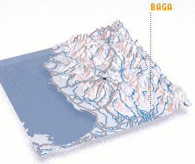 Places with similar names to Baga, Philippines ::
Disclaimer :: Information on this page comes without warranty of any kind |
||
|
Where is Baga? Elevation and coordinates ::
Latitude (lat): 16°3'0"N Longitude (lon): 120°45'0"E
Elevation (approx.): 66m (map arrows pan, magnifying glasses zoom) |
||
|
Visiting Baga? Hotel/Accommodation ::
Book a hotel in Baga Travel Guide ::
Buy a travel guide for Philippines rental cars ::
car rental offers GPS waypoint ::
download a GPX waypoint (PoI) of Baga for your GPS receiver
|
||