|
search place name
|
||
Balisong (Benguet, Philippines)Balisong is a town in the Benguet region of Philippines. An overview map of the region around Balisong is displayed below.
regional and 3d topo map of Balisong, Philippines ::

Balisong airports ::
The nearest airport is BAG - Baguio, located 54.6 km south of Balisong.
Nearby towns ::
Caang (1.8km north west) //
Barbarit (1.9km south) //
Tanap (1.9km south) //
Bino (2.0km south west) //
Balbalit (2.6km west) //
Nayapyap (3.7km north) //
Soocan (3.5km west) //
Bagu (3.7km south) //
Duang (5.6km south) //
Obod (5.6km west) //
Limu (5.6km west) //
Mangta (5.8km south) //
Bito (7.1km east) //
Pidpid (7.1km west) //
Dalingoan (7.4km south) //
Sinadca (7.3km east) //
Pandayan (7.3km west) //
Singa (7.3km west) //
Liblibo (7.3km west) //
Picau (7.3km west) //
Dupay (7.3km west) //
Bakun (8.3km south) //
Bitlingan (8.2km north east) //
Dinasayan (8.0km south east) //
Kayapa (8.2km south west) //
Tamoroog (8.7km south west) //
Kili (9.0km south east) //
Dalipey (9.1km south east) //
Tibo (9.3km north west) //
[all distances 'as the bird flies' and approximate] 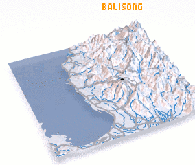 Places with similar names to Balisong, Philippines ::
// Balasing (PH)
// Balisong (PH)
// Balisong (PH)
// Balisong (PH)
// Bolisong (PH)
// Booloosong (PH)
// Balessing (CM)
// Blessing (US)
// Białężynek (PL)
// Blizianka (PL)
Disclaimer :: Information on this page comes without warranty of any kind |
||
|
Where is Balisong? Elevation and coordinates ::
Latitude (lat): 16°52'0"N Longitude (lon): 120°40'0"E
Elevation (approx.): 1269m (map arrows pan, magnifying glasses zoom) |
||
|
Visiting Balisong? Hotel/Accommodation ::
Book a hotel in Balisong Travel Guide ::
Buy a travel guide for Philippines rental cars ::
car rental offers GPS waypoint ::
download a GPX waypoint (PoI) of Balisong for your GPS receiver
|
||