|
search place name
|
||
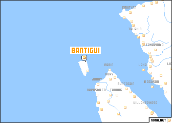
Bantigui (Leyte, Philippines)Bantigui is a town in the Leyte region of Philippines. An overview map of the region around Bantigui is displayed below.
regional and 3d topo map of Bantigui, Philippines ::
Bantigui airports ::
The nearest airport is TAC - Tacloban Daniel Z Romualdez, located 91.6 km south east of Bantigui.
Other airports nearby include NOP - Masbate Mactan Cebu Intl (144.6 km south), BCD - Bacolod (179.6 km south west), KLO - Kalibo (206.8 km west), ILO - Iloilo (211.5 km south west), Nearby towns ::
Gigantangan (2.1km south) //
Rabin (5.4km east) //
Jubay (5.6km south east) //
Ubay (6.4km south east) //
Ynalad (7.1km south east) //
Baras Daco (7.7km south) //
Anislangan (9.0km south east) //
Pananawan (9.9km south east) //
Tabong (9.9km south east) //
[all distances 'as the bird flies' and approximate] 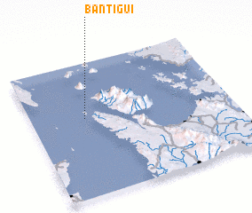 Places with similar names to Bantigui, Philippines ::
Disclaimer :: Information on this page comes without warranty of any kind |
||
|
Where is Bantigui? Elevation and coordinates ::
Latitude (lat): 11°34'59"N Longitude (lon): 124°16'12"E
Elevation (approx.): -32768m (map arrows pan, magnifying glasses zoom) |
||
|
Visiting Bantigui? Hotel/Accommodation ::
Book a hotel in Bantigui Travel Guide ::
Buy a travel guide for Philippines rental cars ::
car rental offers GPS waypoint ::
download a GPX waypoint (PoI) of Bantigui for your GPS receiver
|
||