|
search place name
|
||
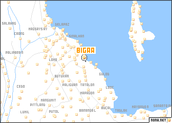
Bigaa (Laguna, Philippines)Bigaa is a town in the Laguna region of Philippines. An overview map of the region around Bigaa is displayed below.
regional and 3d topo map of Bigaa, Philippines ::
Bigaa airports ::
The nearest airport is MNL - Manila Ninoy Aquino Intl, located 27.0 km north west of Bigaa.
Nearby towns ::
Butong (1.1km east) //
Cabuyao (1.3km south) //
Caingin (1.7km north) //
Puntod (2.0km south) //
Dita (2.1km west) //
Sala (2.4km south) //
Wawang Bato (2.3km east) //
Marinig (2.4km south east) //
Pook (2.4km north west) //
Dila (2.4km west) //
Ibaba (2.5km north west) //
Balibago (2.6km west) //
Labas (2.8km north west) //
Malitlit (3.1km south west) //
Niugan (3.2km south) //
Santa Rosa (3.2km north west) //
Aplaya (3.7km north) //
Macabling (3.6km west) //
Banaybanay (4.1km south) //
Tagapo (4.0km north west) //
Putod (4.4km north west) //
Itaas (4.4km north west) //
Cacawate (4.5km south) //
Sinalhan (4.7km north) //
Zapote (4.8km north west) //
Santa Cruz (4.9km west) //
Culong (5.0km west) //
Boagkoan (5.1km west) //
Platero (5.2km north west) //
[all distances 'as the bird flies' and approximate]  Places with similar names to Bigaa, Philippines ::
Disclaimer :: Information on this page comes without warranty of any kind |
||
|
Where is Bigaa? Elevation and coordinates ::
Latitude (lat): 14°17'20"N Longitude (lon): 121°7'45"E
Elevation (approx.): 6m (map arrows pan, magnifying glasses zoom) |
||
|
Visiting Bigaa? Hotel/Accommodation ::
Book a hotel in Bigaa Travel Guide ::
Buy a travel guide for Philippines rental cars ::
car rental offers GPS waypoint ::
download a GPX waypoint (PoI) of Bigaa for your GPS receiver
|
||