|
search place name
|
||
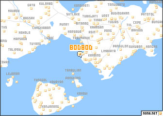
Bodbod (Sulu, Philippines)Bodbod is a town in the Sulu region of Philippines. An overview map of the region around Bodbod is displayed below.
regional and 3d topo map of Bodbod, Philippines ::
Bodbod airports ::
The nearest airport is ZAM - Zamboanga Intl, located 145.4 km north east of Bodbod.
Nearby towns ::
Siyunuyan (0.9km east) //
Kuta Asin (1.0km north east) //
Pandanpandan (1.2km south east) //
Digpin (1.7km north east) //
Bunan (1.9km east) //
Dundang (2.1km north east) //
Cottab (2.3km east) //
Asin (2.8km north east) //
Kambing (3.0km east) //
Digpi (3.3km east) //
Magupit (3.4km east) //
Bowol (3.4km east) //
Tabu” Manuk (3.7km north) //
Karungdung (3.8km south east) //
Kalingalan Caluang (3.9km east) //
Tambulian (4.1km south west) //
Tongol (4.2km north east) //
Campo (4.2km east) //
Bangoal (4.5km east) //
Kulay-Kulay (5.0km north) //
Busay (5.2km north east) //
Sang (5.2km south east) //
Marsada (5.4km north) //
Kangadjal (5.5km north east) //
Asin (5.6km north east) //
Pongdong (5.9km south) //
Sungab (5.9km south east) //
Baubu (6.0km north east) //
Sapa Bagan (6.2km east) //
[all distances 'as the bird flies' and approximate]  Places with similar names to Bodbod, Philippines ::
Disclaimer :: Information on this page comes without warranty of any kind |
||
|
Where is Bodbod? Elevation and coordinates ::
Latitude (lat): 5°54'0"N Longitude (lon): 121°14'0"E
(map arrows pan, magnifying glasses zoom) |
||
|
Visiting Bodbod? Hotel/Accommodation ::
Book a hotel in Bodbod Travel Guide ::
Buy a travel guide for Philippines rental cars ::
car rental offers GPS waypoint ::
download a GPX waypoint (PoI) of Bodbod for your GPS receiver
|
||