|
search place name
|
||
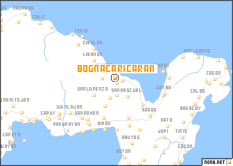
Bogna-Caricaran (Sorsogon, Philippines)Bogna-Caricaran is a town in the Sorsogon region of Philippines. An overview map of the region around Bogna-Caricaran is displayed below.
regional and 3d topo map of Bogna-Caricaran, Philippines ::
Bogna-Caricaran airports ::
The nearest airport is TAC - Tacloban Daniel Z Romualdez, located 227.2 km south east of Bogna-Caricaran.
Other airports nearby include KLO - Kalibo (234.3 km south west), Nearby towns ::
Del Rosario (0.0km north) //
San Luis (0.0km north) //
Santo Domingo (0.0km north) //
Bacon (1.0km north east) //
San Isidro (1.9km south) //
Santa Cruz (2.4km west) //
San Roque (2.6km south west) //
Himaog (2.6km north west) //
Cagpandan (2.6km north east) //
Cabarbohan (2.6km north east) //
San Pascual (2.7km south east) //
San Lorenzo (4.1km south west) //
Gabao (4.1km south west) //
Libanon (5.2km north west) //
San Juan (5.2km north west) //
Salvacion (5.3km south east) //
San Vicente (5.8km south) //
San Ramon (5.8km south) //
Bibincahan (5.9km south) //
Cibulan (6.6km north west) //
Buhatan (7.1km south) //
Pahal (7.4km south) //
Sugod (7.4km south east) //
San Ramon (7.4km south west) //
Sipak (7.6km south) //
Esteban (7.5km east) //
Bonot (7.5km east) //
Pangpang (7.8km south west) //
Gatbo (7.7km east) //
[all distances 'as the bird flies' and approximate] 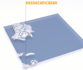 Places with similar names to Bogna-Caricaran, Philippines :: Disclaimer :: Information on this page comes without warranty of any kind |
||
|
Where is Bogna-Caricaran? Elevation and coordinates ::
Latitude (lat): 13°2'0"N Longitude (lon): 124°2'0"E
Elevation (approx.): 21m (map arrows pan, magnifying glasses zoom) |
||
|
Visiting Bogna-Caricaran? Hotel/Accommodation ::
Book a hotel in Bogna-Caricaran Travel Guide ::
Buy a travel guide for Philippines rental cars ::
car rental offers GPS waypoint ::
download a GPX waypoint (PoI) of Bogna-Caricaran for your GPS receiver
|
||