|
search place name
|
||
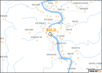
Bulu (Isabela, Philippines)Bulu is a town in the Isabela region of Philippines. An overview map of the region around Bulu is displayed below.
regional and 3d topo map of Bulu, Philippines ::
Bulu airports ::
The nearest airport is BAG - Baguio, located 161.8 km south west of Bulu.
Nearby towns ::
Pilig (1.3km north east) //
Quibal (1.4km west) //
Fugu Norte (1.8km east) //
Langa (1.8km east) //
Asuacan (1.8km east) //
Ragan Norte (1.9km south) //
Lattu (2.2km north west) //
Asin Boji (2.3km east) //
Calingan (2.6km north west) //
Magsaysay (2.8km south east) //
San Francisco (2.9km north east) //
Tunggi (2.9km north east) //
Sinipil (3.2km east) //
San Juan (3.3km south east) //
Banco (3.7km north) //
Lanna (4.0km east) //
Colinauan (4.3km north west) //
Pelio (4.6km north east) //
Antagan (5.2km north) //
Alto (5.1km north east) //
Calinauan (5.1km north west) //
Andarayan (5.1km west) //
Abbuatan (5.3km south east) //
Ugad (6.5km south east) //
Malamag (6.6km south east) //
Anguapan (6.6km south east) //
Bayabo (6.6km south east) //
Cali (6.6km south east) //
Camasi (6.6km south east) //
[all distances 'as the bird flies' and approximate] 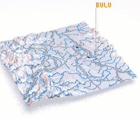 Places with similar names to Bulu, Philippines ::
Disclaimer :: Information on this page comes without warranty of any kind |
||
|
Where is Bulu? Elevation and coordinates ::
Latitude (lat): 17°20'0"N Longitude (lon): 121°46'0"E
Elevation (approx.): 32m (map arrows pan, magnifying glasses zoom) |
||
|
Visiting Bulu? Hotel/Accommodation ::
Book a hotel in Bulu Travel Guide ::
Buy a travel guide for Philippines rental cars ::
car rental offers GPS waypoint ::
download a GPX waypoint (PoI) of Bulu for your GPS receiver
|
||