|
search place name
|
||
Bungol (La Union, Philippines)Bungol is a town in the La Union region of Philippines. An overview map of the region around Bungol is displayed below.
regional and 3d topo map of Bungol, Philippines ::

Bungol airports ::
The nearest airport is BAG - Baguio, located 49.7 km south east of Bungol.
Nearby towns ::
Ar-Arumpang (1.8km north east) //
Napaset (2.3km west) //
Corrooy (2.7km north east) //
Masupe (3.3km north east) //
Camiling (3.3km north east) //
Apatot (3.2km north west) //
Guinabang (3.4km south west) //
Calautit (3.4km south west) //
Bacqui (3.4km south west) //
Santa Rita (3.6km south west) //
Nagsabaran Norte (3.7km north west) //
Nagsabaran Sur (3.7km north west) //
Mabanengbeng Second (4.2km west) //
Butubut Sur (4.3km north east) //
Pao (4.3km north east) //
Lipay (4.3km north east) //
Tal-li-pugo (4.9km north) //
Sablot (4.9km north) //
San Pablo (4.9km north) //
Butubut Oeste (4.9km north) //
Napaset (4.9km north) //
Pagleddegan (4.9km north) //
Calungbuyan (4.9km north) //
Nalasin (4.9km north) //
Bet-ang (4.9km north) //
Guinaburan (4.9km north) //
Butubut Este (4.9km north) //
Bitalag (4.7km south west) //
Sapilang (4.9km south west) //
[all distances 'as the bird flies' and approximate] 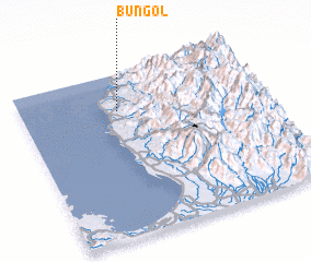 Places with similar names to Bungol, Philippines ::
Disclaimer :: Information on this page comes without warranty of any kind |
||
|
Where is Bungol? Elevation and coordinates ::
Latitude (lat): 16°46'23"N Longitude (lon): 120°24'15"E
Elevation (approx.): 53m (map arrows pan, magnifying glasses zoom) |
||
|
Visiting Bungol? Hotel/Accommodation ::
Book a hotel in Bungol Travel Guide ::
Buy a travel guide for Philippines rental cars ::
car rental offers GPS waypoint ::
download a GPX waypoint (PoI) of Bungol for your GPS receiver
|
||