|
search place name
|
||
Caalibambangan (Nueva Ecija, Philippines)Caalibambangan is a town in the Nueva Ecija region of Philippines. An overview map of the region around Caalibambangan is displayed below.
regional and 3d topo map of Caalibambangan, Philippines ::

Caalibambangan airports ::
The nearest airport is BAG - Baguio, located 99.0 km north of Caalibambangan.
Other airports nearby include MNL - Manila Ninoy Aquino Intl (113.8 km south), Nearby towns ::
Alibangbang (1.6km south) //
Pinagpanaan (1.9km north) //
Umangan (2.4km south west) //
Buliran (2.6km north east) //
Dalampang (2.7km east) //
Mayapyap (2.8km south east) //
Bulos (3.5km north west) //
Samon (3.7km south) //
Baluga (3.8km north east) //
Valdefluente (3.9km south east) //
La Torre (4.0km north) //
Cinco Cinco (4.1km south west) //
San Roque (4.1km south west) //
Mamandil (4.0km north west) //
Pagas (4.1km south east) //
Bantug (4.1km north west) //
Sapang (4.0km south east) //
San Felipe (4.5km south west) //
Catambuan (5.1km north west) //
Magat (5.1km north west) //
Aduas (5.1km south east) //
Sañgitan (5.2km south east) //
Talipapa Norte (5.6km south) //
Talipapa Sur (5.6km south) //
Balite (5.4km east) //
Dolores (5.7km north west) //
Homestead (5.8km north) //
Gulod (5.8km north) //
San Miguel na Munti (5.8km north) //
[all distances 'as the bird flies' and approximate] 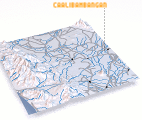 Places with similar names to Caalibambangan, Philippines :: Disclaimer :: Information on this page comes without warranty of any kind |
||
|
Where is Caalibambangan? Elevation and coordinates ::
Latitude (lat): 15°32'0"N Longitude (lon): 120°56'0"E
Elevation (approx.): 38m (map arrows pan, magnifying glasses zoom) |
||
|
Visiting Caalibambangan? Hotel/Accommodation ::
Book a hotel in Caalibambangan Travel Guide ::
Buy a travel guide for Philippines rental cars ::
car rental offers GPS waypoint ::
download a GPX waypoint (PoI) of Caalibambangan for your GPS receiver
|
||