|
search place name
|
||
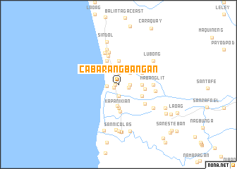
Cabarangbañgan (Zambales, Philippines)Cabarangbañgan is a town in the Zambales region of Philippines. An overview map of the region around Cabarangbañgan is displayed below.
regional and 3d topo map of Cabarangbañgan, Philippines ::
Cabarangbañgan airports ::
The nearest airport is MNL - Manila Ninoy Aquino Intl, located 115.4 km south east of Cabarangbañgan.
Other airports nearby include BAG - Baguio (160.9 km north), Nearby towns ::
San Narciso (0.5km west) //
Natividad (0.9km south west) //
San Pascual (1.7km east) //
Paete (1.9km north) //
Candelaria (1.8km east) //
Mabangcal (1.9km south) //
La Paz (1.8km west) //
Lara (2.6km north east) //
Mabanocal (3.4km south) //
Duque (3.7km north) //
Dal-lipawen (3.6km east) //
Kapanikian (3.7km south) //
Mindoro (4.1km north west) //
Baloncaguing (4.0km north east) //
Pait (4.0km north east) //
Santiago (4.0km south east) //
Namatacan (4.1km east) //
Beddeng (4.3km south) //
San Rafael (4.8km north) //
Siminublan (5.0km south east) //
San Felipe (5.3km north) //
Santo Niño (5.4km north west) //
Mabanglit (5.4km east) //
Balincaguing (5.7km north east) //
Aguimatang (5.8km north) //
Umaya (5.8km east) //
Lubong (6.5km north east) //
Nagsabong (6.5km south east) //
Sindol (6.9km north) //
[all distances 'as the bird flies' and approximate]  Places with similar names to Cabarangbañgan, Philippines :: Disclaimer :: Information on this page comes without warranty of any kind |
||
|
Where is Cabarangbañgan? Elevation and coordinates ::
Latitude (lat): 15°1'0"N Longitude (lon): 120°5'0"E
Elevation (approx.): 16m (map arrows pan, magnifying glasses zoom) |
||
|
Visiting Cabarangbañgan? Hotel/Accommodation ::
Book a hotel in Cabarangbañgan Travel Guide ::
Buy a travel guide for Philippines rental cars ::
car rental offers GPS waypoint ::
download a GPX waypoint (PoI) of Cabarangbañgan for your GPS receiver
|
||