|
search place name
|
||
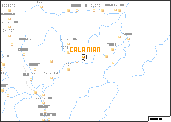
Calanian (Kalinga-Apayao, Philippines)Calanian is a town in the Kalinga-Apayao region of Philippines. An overview map of the region around Calanian is displayed below.
regional and 3d topo map of Calanian, Philippines ::
Calanian airports ::
The nearest airport is BAG - Baguio, located 201.8 km south of Calanian.
Nearby towns ::
Guenned (1.8km west) //
Waga (4.0km south west) //
Magabubun (4.0km north west) //
Aripip (4.5km east) //
Banbanuag (5.1km north west) //
Maabayan (5.9km east) //
Tauit (6.2km north east) //
Gubuc (7.0km west) //
Majabta (8.0km south west) //
Bulu (8.2km south west) //
Capinatan (8.8km north east) //
[all distances 'as the bird flies' and approximate] 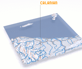 Places with similar names to Calanian, Philippines ::
// Kalinino (AZ)
// Calaanan (PH)
// Calaanan (PH)
// Calañan (PH)
// Calanan (PH)
// Calao-anan (PH)
// Calauan-on (PH)
// Calinauan (PH)
// Colinauan (PH)
// Culanan (PH)
Disclaimer :: Information on this page comes without warranty of any kind |
||
|
Where is Calanian? Elevation and coordinates ::
Latitude (lat): 18°5'0"N Longitude (lon): 121°17'0"E
Elevation (approx.): 214m (map arrows pan, magnifying glasses zoom) |
||
|
Visiting Calanian? Hotel/Accommodation ::
Book a hotel in Calanian Travel Guide ::
Buy a travel guide for Philippines rental cars ::
car rental offers GPS waypoint ::
download a GPX waypoint (PoI) of Calanian for your GPS receiver
|
||