|
search place name
|
||
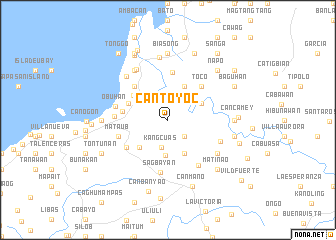
Cantoyoc (Bohol, Philippines)Cantoyoc is a town in the Bohol region of Philippines. An overview map of the region around Cantoyoc is displayed below.
regional and 3d topo map of Cantoyoc, Philippines ::
Cantoyoc airports ::
The nearest airport is NOP - Masbate Mactan Cebu Intl, located 40.0 km north of Cantoyoc.
Other airports nearby include DGT - Dumaguete (112.3 km south west), BCD - Bacolod (148.4 km north west), TAC - Tacloban Daniel Z Romualdez (172.5 km north east), CGY - Ladag Cagayan De Oro (180.5 km south), Nearby towns ::
Canmaya Dacu (2.6km south east) //
Kangcuas (3.2km south) //
Pangliogan (4.0km south) //
Banahao (4.1km north east) //
Balicuing (4.1km north east) //
Bahan (4.1km south east) //
Canmaya (4.4km south west) //
Lutao (4.7km north west) //
U-ong (4.7km north west) //
Nahawan (5.1km west) //
Cogon (5.2km north west) //
Pangi (5.2km north east) //
Toco (5.2km north east) //
Liloan Norte (5.3km north) //
Caboy (5.5km south west) //
Mataub (5.8km west) //
Kabawan (5.8km west) //
Bacani (5.9km west) //
Sagbayan (6.0km south) //
Obuhan (5.9km west) //
Sapinitan (6.1km south east) //
Magtangtang (6.3km east) //
Lusong (6.6km north west) //
Cailig (6.7km north west) //
Panasan (6.6km south east) //
Bacayan (6.6km north west) //
Nabuad (7.0km north) //
Biasong (7.4km north) //
Comaang (7.3km west) //
[all distances 'as the bird flies' and approximate] 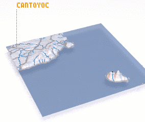 Places with similar names to Cantoyoc, Philippines ::
Disclaimer :: Information on this page comes without warranty of any kind |
||
|
Where is Cantoyoc? Elevation and coordinates ::
Latitude (lat): 9°58'0"N Longitude (lon): 124°6'0"E
Elevation (approx.): 132m (map arrows pan, magnifying glasses zoom) |
||
|
Visiting Cantoyoc? Hotel/Accommodation ::
Book a hotel in Cantoyoc Travel Guide ::
Buy a travel guide for Philippines rental cars ::
car rental offers GPS waypoint ::
download a GPX waypoint (PoI) of Cantoyoc for your GPS receiver
|
||