|
search place name
|
||
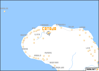
Cataja (Romblon, Philippines)Cataja is a town in the Romblon region of Philippines. An overview map of the region around Cataja is displayed below.
regional and 3d topo map of Cataja, Philippines ::
Cataja airports ::
The nearest airport is KLO - Kalibo, located 88.7 km south of Cataja.
Other airports nearby include ILO - Iloilo (194.2 km south), SJI - San Jose Antique (198.9 km south), BCD - Bacolod (206.9 km south), Nearby towns ::
Tampayan (1.2km north) //
Magdiwang (2.5km north) //
Dulangan (2.5km south west) //
Jao-asan (2.7km north west) //
Canouac (3.3km north west) //
Ilaya (4.3km west) //
Ambulong (4.4km north west) //
Luzong (4.9km north west) //
Agnoknok (5.2km north east) //
Ipil (5.3km west) //
Basiay (5.9km west) //
Pisi (6.0km west) //
Boac (6.3km south west) //
Agsao (6.9km west) //
Culongculong (7.2km west) //
Oyan (7.6km south) //
Punong (7.6km south) //
Canmasanag (7.9km south) //
Malubago (8.4km west) //
Silum (8.5km east) //
Gulam (8.9km south) //
Apiag (9.2km south) //
Mabulo (9.6km south west) //
Canlapinig (10.0km south west) //
Mabini (10.1km south west) //
Bulabug (10.7km south west) //
[all distances 'as the bird flies' and approximate] 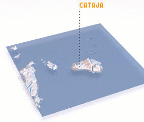 Places with similar names to Cataja, Philippines ::
Disclaimer :: Information on this page comes without warranty of any kind |
||
|
Where is Cataja? Elevation and coordinates ::
Latitude (lat): 12°28'7"N Longitude (lon): 122°31'10"E
Elevation (approx.): 35m (map arrows pan, magnifying glasses zoom) |
||
|
Visiting Cataja? Hotel/Accommodation ::
Book a hotel in Cataja Travel Guide ::
Buy a travel guide for Philippines rental cars ::
car rental offers GPS waypoint ::
download a GPX waypoint (PoI) of Cataja for your GPS receiver
|
||