|
search place name
|
||
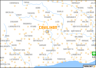
Cawilihan (Iloilo, Philippines)Cawilihan is a town in the Iloilo region of Philippines. An overview map of the region around Cawilihan is displayed below.
regional and 3d topo map of Cawilihan, Philippines ::
Cawilihan airports ::
The nearest airport is ILO - Iloilo, located 19.3 km south east of Cawilihan.
Other airports nearby include SJI - San Jose Antique (49.2 km west), BCD - Bacolod (61.8 km east), KLO - Kalibo (99.1 km north), NOP - Masbate Mactan Cebu Intl (182.5 km east), Nearby towns ::
Nalbang (0.0km north) //
Samlague (0.0km north) //
Magcapay (0.0km north) //
Manampunay (0.0km north) //
Pangdan (0.0km north) //
Pagá (0.0km north) //
Lang-og (0.0km north) //
Maliao Pongco (0.0km north) //
Lanag (0.0km north) //
Jamog (0.0km north) //
Lampaya (0.0km north) //
Isian Victoria (0.0km north) //
Ligtos (0.0km north) //
Baje (0.0km north) //
Carara-an (0.0km north) //
Capitan Fernando (0.0km north) //
Cabuñga-an (0.0km north) //
Cabolo-an (0.0km north) //
Barangbang (0.0km north) //
Dusacan (0.0km north) //
Biri Sur (0.0km north) //
Bulwang-Camandag (0.0km north) //
Buenavista (0.0km north) //
Igcadios (0.0km north) //
Bobon (0.0km north) //
Coyugan Sur (0.0km north) //
Biri Norte (0.0km north) //
Siol Norte (0.0km north) //
San Alejandro (0.0km north) //
[all distances 'as the bird flies' and approximate] 
Disclaimer :: Information on this page comes without warranty of any kind |
||
|
Where is Cawilihan? Elevation and coordinates ::
Latitude (lat): 10°47'0"N Longitude (lon): 122°23'0"E
Elevation (approx.): 74m (map arrows pan, magnifying glasses zoom) |
||
|
Visiting Cawilihan? Hotel/Accommodation ::
Book a hotel in Cawilihan Travel Guide ::
Buy a travel guide for Philippines rental cars ::
car rental offers GPS waypoint ::
download a GPX waypoint (PoI) of Cawilihan for your GPS receiver
|
||