|
search place name
|
||
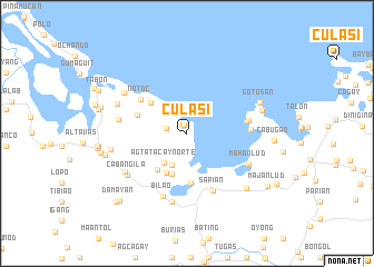
Culasi (Aklan, Philippines)Culasi is a town in the Aklan region of Philippines. An overview map of the region around Culasi is displayed below.
regional and 3d topo map of Culasi, Philippines ::
Culasi airports ::
The nearest airport is KLO - Kalibo, located 26.7 km north west of Culasi.
Other airports nearby include ILO - Iloilo (92.1 km south), BCD - Bacolod (106.9 km south), SJI - San Jose Antique (111.4 km south west), NOP - Masbate Mactan Cebu Intl (205.3 km south east), Nearby towns ::
Kamansi (0.9km north) //
Camance (2.1km west) //
Agsilab (3.5km south west) //
Agtatacay Norte (3.7km south west) //
Lanay (4.3km south) //
Agtatacay Sur (4.4km south west) //
Mambuquiao (4.6km north west) //
Lonoy (4.7km south west) //
Agsilab (5.0km south) //
Napti (5.2km west) //
Notoc (5.7km north west) //
Sapi-an (6.3km south east) //
Dinogmaan (6.2km east) //
Basiao (6.3km east) //
Bilao (6.7km south) //
Mahanlud (6.7km south east) //
Maninang (7.0km south) //
Palay (6.9km west) //
Cabangila (7.1km south west) //
Cabangila (7.2km south west) //
Angas (7.4km north west) //
Mandong (7.4km north west) //
Angas (7.7km west) //
Balaring (7.7km east) //
Gotosan (7.8km north east) //
Dapdapan (8.1km south east) //
Jimeno (8.3km west) //
Cabugao (8.6km east) //
Man-up (8.7km west) //
[all distances 'as the bird flies' and approximate] 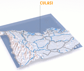 Places with similar names to Culasi, Philippines ::
Disclaimer :: Information on this page comes without warranty of any kind |
||
|
Where is Culasi? Elevation and coordinates ::
Latitude (lat): 11°32'42"N Longitude (lon): 122°34'48"E
Elevation (approx.): 17m (map arrows pan, magnifying glasses zoom) |
||
|
Visiting Culasi? Hotel/Accommodation ::
Book a hotel in Culasi Travel Guide ::
Buy a travel guide for Philippines rental cars ::
car rental offers GPS waypoint ::
download a GPX waypoint (PoI) of Culasi for your GPS receiver
|
||