|
search place name
|
||
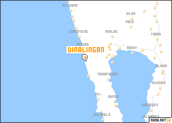
Dinalingan (Surigao del Norte, Philippines)Dinalingan is a town in the Surigao del Norte region of Philippines. An overview map of the region around Dinalingan is displayed below.
regional and 3d topo map of Dinalingan, Philippines ::
Dinalingan airports ::
The nearest airport is CGY - Ladag Cagayan De Oro, located 151.7 km south west of Dinalingan.
Other airports nearby include NOP - Masbate Mactan Cebu Intl (181.6 km north west), TAC - Tacloban Daniel Z Romualdez (194.2 km north), LGP - Legazpi Pagadian (286.6 km south west), Nearby towns ::
Cantopoy (1.5km north) //
Masgad (2.7km north) //
Cantapoy (3.1km south) //
Canitlog (4.5km east) //
Mansayao (5.1km east) //
Cansayong (5.6km north) //
Bayogo (5.6km east) //
Matinao (5.9km north east) //
Paynasa (5.9km north east) //
San Francisco (6.0km east) //
Tagboyaoan (6.1km south east) //
Mayag (6.5km north east) //
Bunyasan (7.6km north) //
Maslog (7.8km north east) //
Tagayan (7.8km east) //
Pili (8.6km south) //
Bunga (10.7km south east) //
[all distances 'as the bird flies' and approximate] 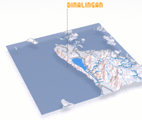 Places with similar names to Dinalingan, Philippines :: Disclaimer :: Information on this page comes without warranty of any kind |
||
|
Where is Dinalingan? Elevation and coordinates ::
Latitude (lat): 9°31'6"N Longitude (lon): 125°25'55"E
Elevation (approx.): 90m (map arrows pan, magnifying glasses zoom) |
||
|
Visiting Dinalingan? Hotel/Accommodation ::
Book a hotel in Dinalingan Travel Guide ::
Buy a travel guide for Philippines rental cars ::
car rental offers GPS waypoint ::
download a GPX waypoint (PoI) of Dinalingan for your GPS receiver
|
||