|
search place name
|
||
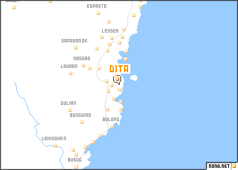
Dita (Zamboanga del Sur, Philippines)Dita is a town in the Zamboanga del Sur region of Philippines. An overview map of the region around Dita is displayed below.
regional and 3d topo map of Dita, Philippines ::
Dita airports ::
The nearest airport is ZAM - Zamboanga Intl, located 33.3 km south west of Dita.
Other airports nearby include LGP - Legazpi Pagadian (152.7 km north east), CEB - Cebu Cotabato (216.5 km east), Nearby towns ::
Timbayan (0.8km south) //
Parangparang (0.8km south) //
Limula (1.1km west) //
Limon (1.7km north) //
Lubigan (2.0km south west) //
Simandal (2.1km west) //
Pilar (2.3km south) //
Panubigan (2.7km south) //
Gulanpan (3.9km south) //
Quinipot (4.1km north west) //
Lawigan (4.2km north) //
Mala (4.2km south west) //
Tuctucalao (5.3km north west) //
Parang-parang (5.4km north) //
Curuan (5.7km north) //
Masaba (6.4km north west) //
Basagan (6.6km north) //
Bolong (6.6km south) //
Balus (6.6km north) //
Lunday (6.8km north west) //
Lessem (7.5km north) //
Binaloy (7.5km north) //
Lawaan (7.8km west) //
Betong (8.0km north) //
Bunguiao (8.2km south west) //
Parmingitan (8.4km south) //
Dulian (8.7km south west) //
Buenavista (8.8km north) //
Sapa Manok (9.0km north west) //
[all distances 'as the bird flies' and approximate] 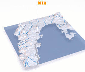 Places with similar names to Dita, Philippines ::
Disclaimer :: Information on this page comes without warranty of any kind |
||
|
Where is Dita? Elevation and coordinates ::
Latitude (lat): 7°9'25"N Longitude (lon): 122°14'57"E
Elevation (approx.): 27m (map arrows pan, magnifying glasses zoom) |
||
|
Visiting Dita? Hotel/Accommodation ::
Book a hotel in Dita Travel Guide ::
Buy a travel guide for Philippines rental cars ::
car rental offers GPS waypoint ::
download a GPX waypoint (PoI) of Dita for your GPS receiver
|
||