|
search place name
|
||
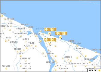
Dodan (Cagayan, Philippines)Dodan is a town in the Cagayan region of Philippines. An overview map of the region around Dodan is displayed below.
regional and 3d topo map of Dodan, Philippines ::
Dodan airports ::
The nearest airport is BAG - Baguio, located 245.3 km south west of Dodan.
Nearby towns ::
Maura (1.8km west) //
Quaal (2.3km south west) //
Badia (2.6km south east) //
Tallungan (2.6km south west) //
Aparri (2.8km west) //
Dodan (3.7km south) //
Badia (3.5km east) //
Fuga Island (4.1km south east) //
Paruddun (4.1km south west) //
Santelmo (4.0km north west) //
Zanja (4.0km south west) //
Toran (4.1km south) //
Dodan (4.1km east) //
Paruddun Norte (4.8km south west) //
Bisagu (4.7km west) //
Catotoran (5.3km south) //
Cacaluan (5.3km west) //
Bangoc (5.6km south) //
Cordician (5.6km south) //
Alilinu (6.0km south) //
Bukig (6.4km south west) //
Paruddun Sur (6.8km south) //
Inuan (7.0km west) //
Abagao (7.4km south) //
Biga (7.4km south) //
Agusi (7.6km south) //
Dacal-Lafugu (7.6km south) //
Yrao (7.3km west) //
Dammang (7.6km south) //
[all distances 'as the bird flies' and approximate] 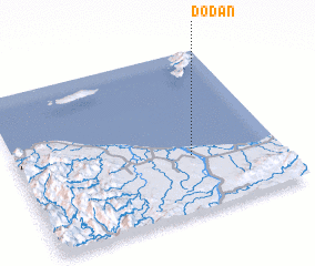 Places with similar names to Dodan, Philippines ::
Disclaimer :: Information on this page comes without warranty of any kind |
||
|
Where is Dodan? Elevation and coordinates ::
Latitude (lat): 18°21'0"N Longitude (lon): 121°40'0"E
Elevation (approx.): 4m (map arrows pan, magnifying glasses zoom) |
||
|
Visiting Dodan? Hotel/Accommodation ::
Book a hotel in Dodan Travel Guide ::
Buy a travel guide for Philippines rental cars ::
car rental offers GPS waypoint ::
download a GPX waypoint (PoI) of Dodan for your GPS receiver
|
||