|
search place name
|
||
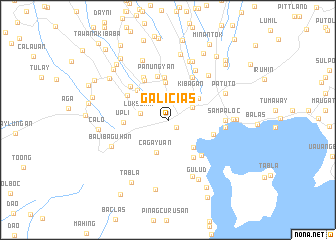
Galicias (Tagaytay, Philippines)Galicias is a town in the Tagaytay region of Philippines. An overview map of the region around Galicias is displayed below.
regional and 3d topo map of Galicias, Philippines ::
Galicias airports ::
The nearest airport is MNL - Manila Ninoy Aquino Intl, located 47.8 km north of Galicias.
Nearby towns ::
Suplang (1.2km south east) //
Tagaytay (3.0km north east) //
Sungay (3.0km north) //
Luksuhin (3.1km west) //
Cagayuan (3.8km south) //
Kibagan (3.9km north east) //
Kaybagal (4.0km north east) //
Balaquilong (4.1km south east) //
Mendez-Nuñez (4.2km north) //
Anuling (4.6km north west) //
Asis (4.7km north) //
Panungyan (5.0km north) //
Upli (4.9km west) //
Bayuyuñgan (5.0km south east) //
Palocpoc (5.1km north west) //
Mangas (5.1km north west) //
Binirayan (5.2km east) //
Carasuchi (5.4km north west) //
Salaban (5.5km north east) //
Laurel (5.4km south east) //
Esperanza (5.6km north west) //
Maitim Segundo (6.3km north east) //
Sampaloc (6.2km east) //
Sugod (6.3km east) //
Maitim (6.6km north east) //
Bugaan (6.9km south east) //
Loma (6.9km north) //
Balibaguhan (6.8km south west) //
Patuto (6.9km north east) //
[all distances 'as the bird flies' and approximate]  Places with similar names to Galicias, Philippines ::
Disclaimer :: Information on this page comes without warranty of any kind |
||
|
Where is Galicias? Elevation and coordinates ::
Latitude (lat): 14°5'26"N Longitude (lon): 120°54'31"E
Elevation (approx.): 658m (map arrows pan, magnifying glasses zoom) |
||
|
Visiting Galicias? Hotel/Accommodation ::
Book a hotel in Galicias Travel Guide ::
Buy a travel guide for Philippines rental cars ::
car rental offers GPS waypoint ::
download a GPX waypoint (PoI) of Galicias for your GPS receiver
|
||