|
search place name
|
||
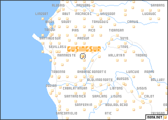
Gusing Sur (La Union, Philippines)Gusing Sur is a town in the La Union region of Philippines. An overview map of the region around Gusing Sur is displayed below.
regional and 3d topo map of Gusing Sur, Philippines ::
Gusing Sur airports ::
The nearest airport is BAG - Baguio, located 33.0 km south east of Gusing Sur.
Nearby towns ::
Tanquigan (0.0km north) //
Masicong (0.0km north) //
Sacyud (1.9km north) //
Banoagan (1.9km south) //
Lioac (1.9km south) //
Baraoas Norte (1.9km south) //
Daramuangan (1.9km south) //
Gusing Norte (1.8km east) //
Mamat-ing Sur (1.8km east) //
Birunget (2.6km north west) //
Cabarsican (2.6km north east) //
Tuddingan (2.6km north east) //
Bimmutubot (3.3km east) //
Pao Sur (3.7km north) //
Narra Este (3.6km west) //
Cabaritan Norte (3.7km south) //
Sili (3.7km south) //
Baraoas Sur (3.7km south) //
Mamat-ing Norte (3.7km north east) //
Naguilian (3.9km south) //
Cadaclan (4.1km north west) //
Narra Oeste (4.0km north west) //
Bungro (4.0km north west) //
Dalipaoen (4.1km south west) //
Ribsuan (4.1km south east) //
Bancagan (4.1km south east) //
Aguioas (4.1km south east) //
Nagsidurisan (4.1km south east) //
Casilagan (4.1km south east) //
[all distances 'as the bird flies' and approximate]  Places with similar names to Gusing Sur, Philippines ::
// Qazanguzar (TJ)
Disclaimer :: Information on this page comes without warranty of any kind |
||
|
Where is Gusing Sur? Elevation and coordinates ::
Latitude (lat): 16°34'0"N Longitude (lon): 120°23'0"E
Elevation (approx.): 92m (map arrows pan, magnifying glasses zoom) |
||
|
Visiting Gusing Sur? Hotel/Accommodation ::
Book a hotel in Gusing Sur Travel Guide ::
Buy a travel guide for Philippines rental cars ::
car rental offers GPS waypoint ::
download a GPX waypoint (PoI) of Gusing Sur for your GPS receiver
|
||