|
search place name
|
||
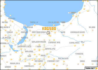
Kagsao (Camarines Sur, Philippines)Kagsao is a town in the Camarines Sur region of Philippines. An overview map of the region around Kagsao is displayed below.
regional and 3d topo map of Kagsao, Philippines ::
Nearby towns ::
San Vicente (0.0km north) //
San Antonio (0.0km north) //
Santa Isabel (0.0km north) //
San Isidro (0.0km north) //
Kabanbanan (0.0km north) //
Quipayo (0.5km south east) //
San Roque (1.8km north east) //
Bombon (2.0km south) //
Calabanga (2.4km north east) //
Santo Domingo (2.6km south west) //
San Jose Pagatpat (2.6km south east) //
Sabang (3.1km north east) //
Santo Domingo (3.6km west) //
Belen (4.0km north east) //
Santo Niño (4.0km north east) //
San Roque (4.1km south west) //
Calalanan (4.1km north east) //
Carangcang (4.5km south east) //
Magarao (4.8km south) //
Casuray (5.2km south west) //
Bell (5.2km south west) //
San Juan-Pagao (5.2km south west) //
Suro (5.4km east) //
San Bernardino (5.4km west) //
Manguirin (5.4km east) //
Borabod (5.4km east) //
San Miguel (5.8km south) //
Baras (5.9km south) //
San Felipe (6.5km south) //
[all distances 'as the bird flies' and approximate] 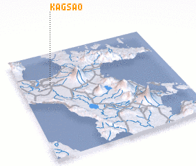 Places with similar names to Kagsao, Philippines ::
Disclaimer :: Information on this page comes without warranty of any kind |
||
|
Where is Kagsao? Elevation and coordinates ::
Latitude (lat): 13°42'0"N Longitude (lon): 123°12'0"E
Elevation (approx.): 3m (map arrows pan, magnifying glasses zoom) |
||
|
Visiting Kagsao? Hotel/Accommodation ::
Book a hotel in Kagsao Travel Guide ::
Buy a travel guide for Philippines rental cars ::
car rental offers GPS waypoint ::
download a GPX waypoint (PoI) of Kagsao for your GPS receiver
|
||