|
search place name
|
||
Kirang (Nueva Vizcaya, Philippines)Kirang is a town in the Nueva Vizcaya region of Philippines. An overview map of the region around Kirang is displayed below.
regional and 3d topo map of Kirang, Philippines ::

Kirang airports ::
The nearest airport is BAG - Baguio, located 43.9 km west of Kirang.
Other airports nearby include MNL - Manila Ninoy Aquino Intl (196.9 km south), Nearby towns ::
Beti (1.5km east) //
Taboung (1.9km north east) //
Comon (1.9km east) //
Bone North (2.6km south) //
Aritao (2.5km north east) //
Allauan (2.7km south east) //
Tabueng (3.9km south east) //
Bone (4.0km south west) //
Banganan (4.2km north east) //
Maginang (4.5km north east) //
Anablan (5.7km west) //
Gabut (6.0km north east) //
Ba-an (6.4km north west) //
Mangayan (6.3km north east) //
Allauan (6.4km east) //
Bone South (6.6km south west) //
Santa Cruz (6.5km north west) //
Santa Maria (6.8km east) //
Santa Rosa (7.6km north west) //
Guableng (7.5km west) //
Bayaong (7.5km west) //
Tolitul (7.5km west) //
Baclungay (7.6km west) //
Buyasyas (7.6km west) //
Tagalog (7.9km north west) //
Dupax del Norte (7.9km east) //
San Francisco (8.1km south east) //
Babuang (8.1km north west) //
Indiana (8.3km north east) //
[all distances 'as the bird flies' and approximate] 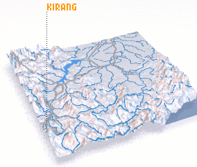 Places with similar names to Kirang, Philippines ::
Disclaimer :: Information on this page comes without warranty of any kind |
||
|
Where is Kirang? Elevation and coordinates ::
Latitude (lat): 16°17'17"N Longitude (lon): 121°1'12"E
Elevation (approx.): 411m (map arrows pan, magnifying glasses zoom) |
||
|
Visiting Kirang? Hotel/Accommodation ::
Book a hotel in Kirang Travel Guide ::
Buy a travel guide for Philippines rental cars ::
car rental offers GPS waypoint ::
download a GPX waypoint (PoI) of Kirang for your GPS receiver
|
||